James Rountree (1787-1834), Pioneer Settler of Old Lowndes

James Rountree (1787-1834)

James Rountree, it is said, was the first pioneer settler to build a house in Old Lowndes County, GA.

James Rountree was a son of William F. and Rachel Rountree, born about 1787 in Burke County, GA. His parents were planters of North Carolina but had come to Burke County some time before James was born.

The research of Robert Jeffries found that James Rountree moved from Burke County about 1808.  He settled in the newly created Telfair County.  Telfair and Laurens counties were created from Wilkinson County by an act of the General Assembly approved December 10, 1807 (Ga. Laws 1807, p. 37).

This map shows Laurens County (upper) and Telfair County (lower) outlined in red to show the original boundaries specified in the Dec. 10, 1807 act creating both counties. http://georgiainfo.galileo.usg.edu/histcountymaps/telfair1807map.htm

This map shows Laurens County (upper) and Telfair County (lower) outlined in red to show the original boundaries specified in the Dec. 10, 1807 act creating both counties. http://georgiainfo.galileo.usg.edu/histcountymaps/telfair1807map.htm

“County Records show that James Rountree, of Burke County, on June 27, 1808, bought Land Lot #319 in the 14th District … from John Hand of Columbia County for $100 as shown in Deed Book A on page 93, and on the same date he bought Land Lot #318 in the same district and county from Elijah Roberson for $500 as shown in Deed Book A on page 94.

Later that year, on December 13, 1808, this section was cut into Pulaski County by an act of the General Assembly (Ga. Laws 1808, p. 52). (Today, the 14th Land District of old Wilkinson County is now wholly in Dodge County, GA.)

“The Pulaski County tax-digest for 1811, shows James Rountree lived on Land Lot #150 of the 14th District of Pulaski, now Dodge County. He was also listed for taxation on Land Lot # 319 in the 14th District of Telfair County, and he owned the following property: 300 acres of land in Montgomery County, which had been granted to him, 342 acres of land in Burke County, which had been granted to him, 300 acres of land in Burke County, which he had bought, and Land Lot #245 in the 5th District of Baldwin County. He also paid taxes on four slaves.”

It appears that James Rountree married about 1810 or 1811, although the record of this marriage and the name of his wife is not known at this time.  There are no extant records of the 1810 census in Georgia, and no records of this marriage have been reported from Burke, Wilkinson, Telfair, Laurens, or Pulaski counties.

What is known from the census of 1820, the 4th U.S. Census in Pulaski County, GA, is that the household of James Rountree there were four white children, three girls and one boy, all under age 10, and ten African-American enslaved people.  There were no free white adult females in his household. One would surmise that James Rountree was a widower, and that his first wife died sometime before 1820, leaving him to raise their four children.

1820 Census enumeration of the household of James Rountree, Pulaski County, GA seemed to indicate he was a widower living with his children and slaves.

1820 Census enumeration of the household of James Rountree, Pulaski County, GA seemed to indicate he was a widower living with his children and enslaved people.
 https://archive.org/stream/populationsc18200009unit#page/n100/mode/1up
http://files.usgwarchives.net/ga/pulaski/census/1820/pg72a.txt

By matching family histories to the 1820 census, the children of James Rountree by his first wife were:

  1. John Rountree- died young
  2. Harriet Rountree (1812-1875); born January 15, 1812; married James McMullen, Jr., October 7, 1830; died November 10, 1873; buried James McMullen Cemetery, Brooks County, GA.
  3. Nancy Rountree (1814-1901); born October 25, 1813; married Clayton Bradshaw; died January 27, 1906, Brooks County, GA; buried John McMullen Cemetery  GroovervilleBrooks CountyGA
  4. Weston W. Rountree (1815-1895); born July 5, 1815; married Edith Elizabeth Folsom, daughter of William Folsom; died February 12, 1895, Lowndes County, GA; buried 
    Salem United Methodist Church Cemetery, Hahira, Lowndes County, GA
  5. Henrietta Rountree (1817-1901); born May, 1817; married Barry Wells, 1833 in Lowndes County, GA; died  ; buried  Berry Wells Family Cemetery, ShilohLowndes County, GA.

James Rountree first came to the southern region of Irwin County, GA in 1815.  According to A History of Savannah and South Georgia, Vol 2:

“Accompanied by three other enterprising and adventurous young men, James Rountree, Drew Vickers and Alfred Belote, [Lawrence Folsom] came to that part of Irwin county now included within the boundaries of Lowndes county, blazing his way through the wilderness on horseback.  

Rountree’s companions were Alfred Belote, Drew Vickers, and Lawrence Folsom.

The blue-eyed, fair-haired, 5’6″ Belote was 22 years old (born 1793). During the War of 1812, Belote was in the reserves with the 10th US Infantry but, according to the National Archives Register of Enlistments in the US Army, he was “discharged April 24, 1815, at Raleigh, NC, term expired, without joining regiment or corps.”  His father, Noah Belote, was a soldier in the Revolutionary War.  Drew Vickers, 40 years old, was a veteran of the Georgia Militia having served in 1793 in Captain Parrott’s Company of Washington County militiaLawrence Armstrong Folsom (1772-1842), at 43 years old was the senior of the group. His father was a Lieutenant in the Georgia Line during the Revolutionary War.  Folsom was also a veteran, having been commissioned an ensign in the Burke County militia on January 23, 1799. Folsom was married to Rachel Vickers; according to Folks Huxford she was a sister of Drew Vickers, but this is not confirmed by other researchers.

After exploring a considerable portion of South Georgia the quartet invested in government land…The four men went back to their homes in Pulaski and Burke counties, Rountree returning to his motherless children.  James Rountree appears in the 1818 Tax Digest of Pulaski County, paying taxes on 405 acres of pinelands and eight enslaved people which were regarded as taxable property.

The census of 1820 enumerates James Rountree in Pulaski County, GA with his children and enslaved people. Among his neighbors were William Hendley, his wife Millie Hendley, and four daughters: Nancy, Martha, Jane, and Sophia.  Also, next door was the Hendley’s son, Horton Hendley and his family. William Hendley was a Scotsman and a veteran of the Revolutionary War, having served in the Virginia Continental Line.

After some time, the four companions (Rountree, Vickers, Belote, and Folsom) made plans for relocating to the southern frontier they had explored in 1815,

Mr. Folsom buying a tract about a mile from Little River; Messrs. Rountree and Vickers located near by; and Mr. Belote purchased land that included the present site of the village of Mineola.

Again, Robert Jeffries reports,

“Irwin County deed records show that James Rountree of Pulaski County on March 6, 1821, bought Land Lot#497 of the 9th district of then Irwin, but later Lowndes County, from Kinchen P. Tyson of Jones County for $220 as recorded in Deed Book A on page 27. Also on October 16, 1821, he bought Land Lot #516 in the same district and county from Joseph Barr of Franklin County for $200 as shown in Deed Book A on page 25.”

The History of Lowndes County, GA reports that in 1821, the four settlers returned to that section of Irwin soon to be cut into Lowndes County. Sections in the north of old Irwin County had been settled and several counties had been laid out.  The families of James Rountree, Drew Vickers, Alfred Belote, and Lawrence Folsom and their African-American enslaved people were the first pioneer families to settle in the original county of Lowndes after moving there in the winter of 1821-1822.

“These gentlemen returned [to south Irwin County, soon to be Lowndes] … with their wives and children, continues A History of Savannah and South Georgia, Vol 2, making the overland trip in carts drawn either by horses or mules, following Indian trails a part of the way, at other times making their own path through the trackless woods. Whenever they came to a stream too deep to ford, they swam their stock across, and built rafts on which to take their carts and household goods across.”

These pioneer families were pathfinders, bushwhacking their way through Wiregrass Georgia. But soon the Georgia General Assembly appropriated funds for construction of a frontier road. It was on December 23, 1822, that General John E. Coffee and Thomas Swain were appointed to superintend the construction. Enoch Hall was employed as one of the overseers for the construction.  Coffee, Swain, and then Governor John Clark were all neighbors and residents of Telfair County, which undoubtedly influenced the selection of the route. This road, soon known as Coffee’s Road, led to the creation of Lowndes County. It ran from Jacksonville on the Ogeechee [Ocmulgee] River in Telfair County, southwesterly through the then county of Irwin (but now Coffee, Irwin, Berrien) through the then county of Lowndes (but now Berrien, Cook and Brooks) into Thomas County and via Thomasville southwardly to the Florida line.   Coffee’s Road passed about seven miles west of Ray City, GA. 

The Coffee Road provided a convenient route between the frontier homesteaders and their family connections in Telfair, Laurens, and Pulaski counties. It appears that about this time, James Rountree left his frontier home to make a return trip to Pulaski County seeking a wife and mother for his young children.   Pulaski county marriage records show James Rountree was married on March 6, 1823, in Pulaski County to Nancy Hendley.  She was the girl next door to Rountree’s Pulaski County property. She was born April 22, 1793, a daughter of William Hendley, Revolutionary Soldier.

1823 marriage certificate of James Rountree and Nancy Hendley, Pulaski County, GA

1823 marriage certificate of James Rountree and Nancy Hendley, Pulaski County, GA

Georgia
Pulaski County

To any ordained minister of the Gospel, Judge, Justice of the Inferior Court, or Justice of the Peace, to celebrate _________
You are hereby authorized and empowered to join in the holy state of matrimony according to the rites and ceremonies of your church James Rountree and Nancy Hendly and in so doing this shall be your sufficient warrant.
Given under my hand this 5th March 1823
Wesley Yarbrough D.C.C.O

The marriage of the with named James Rountree and Nancy Hendly was solomnized on the 6th March 1823 – W B McGehee J.P.

Entered by Wesley Yarbrough Clk Co

James Rountree took his bride back to his South Georgia place. That year, 1823 James’ brother, Francis Rountree, also came south to homestead.  The home of Francis Rountree near the Withlacoochee River shortly became the center of governmental affairs for the county: “On November 30, 1826, the county site of Lowndes County was changed from the house of Sion Hall to the house of Francis Rountree,” according to the Digest of Georgia.

The children of James Rountree and Nancy Hendley were:

  1. James Lester Rountree (1823-1905) 
  2. Annie B. Rountree (1826-1910); born January 1826, she was one of the first children to be born in Lowndes County, GA; married James Folsom, son of Lawrence Folsom.
  3. Georgia Ann Rountree (1834-1922); married J. W. Anderson; moved to Madison, FL

Of course, with the opening of Coffee Road and the creation of Lowndes County, many more settlers moved into South Georgia. Among the new arrivals were Jesse W. Hunter, Enoch Hall, Sion Hall, Hamilton Sharpe, David Mathis, Daniel McCranie and the families of William Anderson Knight and his son Levi J. Knight, who was the first to settle at the present-day site of Ray City, GA.

James Rountree appears in the 1830 Tax Digest of Lowndes County, and he paid taxes on Land Lots #451, 497, and 516 in the 9th District. The Rountree home and plantation was on Land Lots 497 and 516.  In 1833, he served on the Grand Jury of Lowndes County.

Of the Rountree, Vickers, Folsom, and Belote families, A History of Savannah and South Georgia, Vol 2, says:

They were pioneers in very truth, being the first permanent white settlers of Lowndes county, more especially of its northern portion. There were no mills in that section of the country for several years thereafter, all the grain being ground in mills operated by hand. They kept sheep and raised cotton, and the women used to card, spin and weave the homespun material from which she fashioned all the garments worn by the family. The wild game found in the forests furnished the early settlers with a large part of their subsistence, while acorns, beech nuts and walnuts were so plentiful that the only need of feeding hogs was to keep them from growing wild, an occasional meal serving for that purpose. Very little ready money was then in circulation in the south, and in the newer settlements few store goods were used, salt, sugar and coffee being the principal articles brought in.

Pioneer settlers like James Rountree or Harmon Gaskins did most of their trading at Tallahassee in the Territory of Florida, at St. Marks or Newport on the Florida Gulf Coast, or traveled to the east to trade at Centerville, GA on the St. Marys River. Historian Folks Huxford wrote, “An occasional trip would be made to Savannah but most of the trips were made to the other points named; these trips were usually about once a year, and would last a week or ten days.” Huxford describes how the men traveled in horse-drawn carts, “In such event of a trip, … a journey made in company with two or three neighbors situated like himself.  They drove their carts sitting astride their horses, and took rest-spells by occasionally walking by the side of the horse.  Such trips had to be made to St. Marks, Fla., or to old Center Village in what is now Charlton county.  

It was on the return from an excursion to the Florida coast that James Rountree met his  death. Robert Jeffries reported:

James Rountree was murdered and robbed… near Tallahassee, Florida…  while enroute to the “salt works” on the Gulf of Mexico for salt. Early residents of Lowndes and adjoining counties made regular periodic trips to the Gulf for salt. From his obituary, in the “Southern Recorder” at Milledgeville in the April 16, 1834 edition, it is learned that Mr. Rountree was murdered on March 26, 1834, at night, in his camp on the road from Tallahassee to Thomasville, enroute home. He was supposedly killed by three Negroes, one of whom had been apprehended at this time. The deceased was possessed of a kind and gentlemanly deportment – an innocent and good man – a valuable pattern of frugality and industry. 

The story of the 1834 murder fueled southern plantation owners’ fears of violence from enslaved people. After the murder of James Roundtree, a group of citizens formed a vigilante committee calling themselves “The Regulators.” The group was organized at the gravesite of Mr. Roundtree and William Lester was elected as the leader. William Lester was a relative of Susan Bradford Eppes (1848-1942), who was born at Pine Hill Plantation, Leon County, FL and grew up hearing the tales of the murder of James Rountree.  The book Creating an Old South describes her later writings about how the “brave ‘Regulators’ led by her relative William Lester caught an interracial gang guarding the booty from a robbery. Then ‘twenty pairs of willing hands did quick work – tree limbs were stout and strong – and five white men and one negro were left hanging high as Haman.”

Rewards were offered for the capture of the two other alleged murderers.  The Governor of the Territory of Florida, William Pope Duval, in the final days of his administration offered a reward of $200 which was matched by the citizens of Tallahassee.

April 18, 1834, reward offered for the murder of James Rountree

April 18, 1834, reward offered for the murder of James Rountree

Georgia Constitutionalist
April 18, 1834

A reward of $200 is offered by the Governor of Florida, and $200 additional by the citizens of Tallahassee, for the apprehension of two runaways charged with the murder of James Roundtree.

The Tallahassee Floridian reported in the July 22, 1837 edition that the murder of Mr. Rountree near the Georgia line had been committed by two African-Americans who had escaped from enslavement named Joe and Crittenden. “The editor of the Floridian claimed that ‘The object of the perpetrators is supposed to have been money, of which the deceased was known to have a small sum,’”   according to a study of  Slave Unrest in Florida published in the Florida Historical Quarterly.

James McMullen served as administrator for the estate of James Rountree, Lowndes County, GA, 1834

James McMullen served as administrator for the estate of James Rountree, Lowndes County, GA, 1834

Milledgeville Federal Union
July 23, 1834

Georgia, Lowndes County

Whereas, James McMullin applies for letters of administration on the estate of James Rountree, late of said county, deceased,

These are, therefore, to cite and admonish all and singular the kindred and creditors of said deceased to be and appear at my office, within the time proscribed by law, to show cause, if any exist, why said letters should not be granted.

Given under my hand at office, this 8th July, 1834.
William Smith, c.c.c.

Related Posts

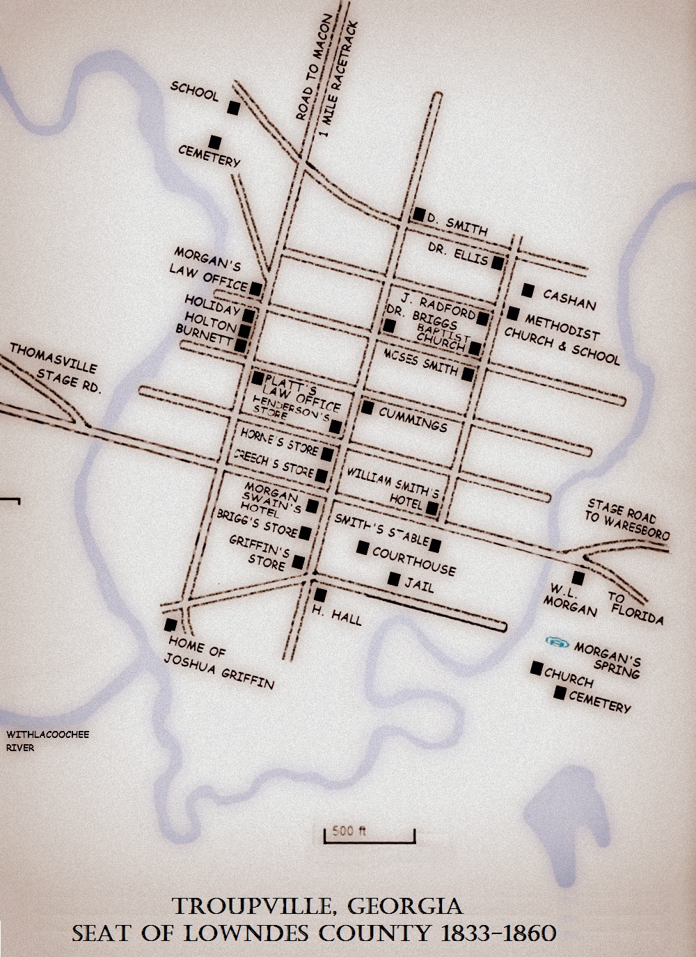
Lowndes County Seat Almost Sunk in 1827

Berrien Skirmishes, the Battle of Brushy Creek, and the Indian Maiden

Grand Jurors of 1845, Lowndes County, GA

Pennywell Folsom Fell at Brushy Creek

A Plank Road for Troupville

In 1852, when all of Berrien County and the site of Ray City, GA, and other surrounding counties were still a part of old Lowndes County, the seat of county government was at Troupville, GA.

Troupville

The people of Troupville aspired to a transportation connection that would link them to the national economy.  Troupville already had a stage road, and a mail route, but the area’s main thoroughfare, the Coffee Road, lay 12 miles to the northwest. Troupville, nestled in the fork of the Withlacoochee River and the Little River, unrealistically dreamed of a river way connection to float goods down to the Gulf of Mexico.  The folks of this section worked to get a railroad line through the town, but when it did come in 1857 the railroad would miss the mark by four miles.

Before that, in 1852, Troupville awaited the construction of a Plank Road which had been authorized by the State legislature.

Plank Road construction

Plank Road construction

The Act to incorporate the Satilla Plank Road Company, approved January 22, 1850, was a part of the decade-long Plank Road Boom which began in 1844.

An Act to Incorporate the Satilla Plank Road Company

An Act to Incorporate the Satilla Plank Road Company

The proposed Satilla Plank Road was to run from the Satilla River, through the Okefenokee Swamp to Troupville, then on to Thomasville and on to the steamboat docks on the Flint River at Bainbridge, GA.  At Thomasville, it could connect with the Florida and Georgia Plank Road, already under construction, which ran to Monticello, FL then on to Newport, FL on the St. Marks River.

Savannah Daily Morning News
January 20, 1852

A Plank Road through the Okefenokee Swamp

The Committee on Internal Improvements in the House, have reported in favor for a plank road through the Okefenokee Swamp to some point on the Flint River. According to the representations of the report, the enterprise is one of vast importance to Southern and South-western Georgia. The Bill reported proposes to grant the company one half of the unsurveyed portion of the swamp on condition that they build a good and sufficient road through the same. The following are the advantages as enumerated in the report:

         Looking upon the map of Georgia, we see the St. Ilia [Satilla], a bold river stretching from the sea coast inland, in a western direction, and navigable for steamers for forty-five miles. Measuring from thence, we pass in almost a direct line through the Okefenokee swamp, through Clinch county to Troupville, in Lowndes county, from thens to Thomasville, in Thomas county, to Bainbridge on the Flint river. The distance from the St. Illa to Bainbridge is one hundred and sixty miles.
          Diverging to the left from Troupville, we reach Monticello, thence to Tallahassee in Florida. The distance from the St. Illa to Tallahassee is one hundred and forty miles. From Monticello to Newport, (the sea port of the Gulf,) the distance is twenty-seven miles, between which places we are informed, a plank road is now being constructed, and some eighteen or twenty miles of which are already completed.
          From the St. Illa to Monticello, the distance is one hundred and thirteen miles, over which, if a plank road were constructed, would give a plank road connection between the shipping port on the Gulf, with a shipping point on the Atlantic side, the entire distance being one hundred and forty miles.
          We are informed the usual rate of freight on plank roads is one cent per bale of cotton, for each mile.
         The freight, then, from Bainbridge to the St. Illa, would be one dollar and sixty cents per bale, and from Tallahassee to the St. Illa, would be one dollar and forty cents per bale, the respective distance being, as before stated, one hundred and sixty miles, and one hundred and forty miles from Bainbridge and Tallahassee to the St. Illa river.
          From the St. Illa, the run can be made to Savannah by steamboats in ten hours, and a fair average rate of freight on cotton, would be forty cents per bale.
          Thus it will be seen that cotton can be transported through this route from Bainbridge to Savannah, from two dollars to two dollars twenty-five cents per bale, and from Tallahassee (in Florida) to Savannah, at one dollar and eighty cents to two dollars per bale.
          The Okefenokee Swamp, stretching as it does from North to South, forty-five to sixty miles, from Georgia into Florida, intercepts and cuts off the trade from a large and fertile portion of our State, and forces its products for shipment, through the Gulf ports in Florida, where the charges attendant on shipment are peculiarly extravagant.
          There is not a planter in Southern or South Western part of our State, but can bear testimony of the heavy charges, high rates of freight and insurance, and vexatious delays attendant on shipments of their produce from the Gulf ports.
          We have before us evidence from a planter of Thomas county, a member of this House, stating that the cost of sending his cotton to Thomasville, through the Gulf ports, to New York, and selling the same there, averages eight dollars per bale.
          It is apparent, then, to your committee, that by opening a plank road communication through the proposed rout, would cause a saving to the planters of the Southern portion of this State of from four to five dollars per bale, and the result would be that the produce of this State, being shipped through the ports of Florida, would in turn draw the products of Florida to Savannah, our own shipping port.

ΙΙΙΙΙΙΙΙΙΙΙΙΙΙΙΙΙΙΙΙΙΙΙΙΙΙΙΙΙΙΙΙΙΙΙΙΙΙΙΙΙΙΙΙΙ

Plank Road Boom

The Plank Road Boom was an economic boom that happened in the United States. Largely in the Eastern United States and New York, the boom lasted from 1844 to the mid 1850s. In about 10 years, over 3,500 miles of plank road were built in New York alone- enough road to go from Manhattan to California, and more than 10,000 miles of plank road were built countrywide.

The Plank Road Boom swept across Georgia, as it did the rest of the nation. At least 16 Plank Road Companies were incorporated in Georgia. By 1847, plank streets were being constructed in Savannah, connecting warehouses and wharves with the railroad. Over the next several years plank roads were planned all over Georgia. In 1849, North Carolina undertook the construction of a plank road connecting Fayetteville, NC to Savannah, GA. In Georgia, a plank road was proposed to run from Griffin to West Point. Another plank road was proposed from Barnesville, GA to the Montgomery Road at Macon.  A plank road was proposed from Washington to Elberton. In 1850, a bill was introduced “to incorporate the Dahlonega and Marietta Turnpike and Plank Road Company; and also to incorporate the Cumming and Atlanta Turnpike and Plank Road Company.” Also, “to incorporate the Cobb county and Alabama Turnpike or Plank Road Company; also, authorizing the construction of a Plank Road from Washington, in Wilkes county, to some point on the Georgia Rail Road.” A plank road was proposed from Albany to Oglethorpe. Among others planned were the Macon, Perry and Albany Plank Road, the Ogeechee Plank Road, the Columbus and Greenville Plank Road, the Atlanta and Sweetwater Plank Road, the Henderson and Marthasville Plank Road, and the Columbus and Lannahassee Plank Road.

 
          Proponents of plank roads stated that plank roads would make it much easier to carry goods and travel in general. They were stated to be 1/3 the cost of gravel roads. Plank roads were said to give a return on investment of 20% They also claimed that the roads will last for at least eight years, and if they don’t, that will be because of more people travelling on the road, which would thus result in more tolls collected. Much of the plank road building occurred in places where lumber was comparatively affordable due to thriving timber industries, as wood was usually over sixty percent of a plank road’s cost.
           National newspapers helped spread the plank road craze. In 1847, Hunts Merchants Magazine published an article titled “Plank Roads-New Improvement.” In 1849, Niles’ Weekly Register said plank roads were “growing into universal favor.” in the 1850s, the New York Tribune praised their ease of construction and said that the roads added a great amount to the transportation abilities of the New York. In March 1850, Scientific American said they viewed plank roads as a means of “completely reforming the interior or rural transit trade of our country.”  In 1852, Hunts Merchants Magazine published an article titled “The First Plank Road Movement,” it extolled plank roads.

In the list of great improvements which have given to this age the character which it will bear in history above all others-the age of happiness to the people-the plank road will have a prominent place, and it deserves it…the plank road is of the class of canals and railways. They are the three great inscriptions graven on the earth by the hand of modern science…

— Hunts Merchants’ Magazine

They also published an editorial saying “every section of the country should be lined with these roads.” Other written items include “Observations on Plank Roads” by George Geddes, “History, Structure and Statistics of Plank Roads in the United States and Canada,” by William Kingsford, and “A Manual of the Principles and Practice of Road-Making” by William M. Gillespie.

 It does not appear that the Satilla Plank Road was ever constructed.
 
Related Posts:
Isham Jordan Fought Indians, Opened Early Wiregrass Roads
Reuben Marsh, Coffee Road Ferryman
The Valdosta Special opened Georgia & Florida Railroad, October 1, 1908
Coffee Road Led to Creation of Lowndes County
Coffee’s Road Passed Seven Miles West of Ray City
Clabberville Road ~ Ray City, GA
 

Henry Blair’s Account of the Skirmish at Cow Creek

In August, 1836 the pioneers of Lowndes and surrounding counties were engaged in local actions against Creek Indians along Warrior Creek, Little River, Alapaha River and at Cow Creek. These Indians were fleeing to Okefenokee Swamp and Florida to escape from forced relocation to the West and presumably to join up with Seminole Indians in Florida.  On the 27th of August, 1836 militia companies commanded by Col. Henry Blair, Captain Lindsay and Captain Levi J. Knight, caught up with a band of Creek Indians at Cow Creek, near present day Statenville, GA (then known as Troublesome Ford.)

In 1830 William Schley became a member of the Georgia House of Representatives. In 1832 and again in 1834, he was elected as a Democrat to the United States House of Representatives. He resigned from that position to become the 36th Governor of Georgia from 1835 until 1837.

In 1830 William Schley became a member of the Georgia House of Representatives. In 1832 and again in 1834, he was elected as a Democrat to the United States House of Representatives. He resigned from that position to become the 36th Governor of Georgia from 1835 until 1837.

Three days later, Col. Henry Blair made his report to Governor William Schley, his letter subsequently being published in state newspapers:

Milledgeville Federal Union
September 20, 1836

Lowndes County, August 30th, 1836.

His Excellency Governor Schley:

        Sir — I have to inform you that a party of Indians were seen in the upper part of this county on Wednesday evening, 24th instant.–
       Next morning, an hour by sun, there was a company of eighteen or twenty men of us in pursuit of them. We trailed them about three miles when we came to their camp where they encamped for the night and appeared to have collected together at that place. We supposed from the sign that there were about sixty-five of seventy of them. We pursued their trail, after dispatching an express to captain Knight at his post to join us with his company, which he did forthwith. We pursued them until Saturday, 27th instant, about half past two o’clock in the evening we came in sight of them where they had stopped to refresh themselves near the line of Ware and Lowndes counties on the side of a large cypress swamp, known by the name of the Cow Creek. When we first saw them at the distance of three or four hundred yards they were running some for the swamp and some from the swamp. As we were marching by heads of companies, a charge was ordered at full speed, which soon brought us within forty or fifty paces of their line where they had posted themselves in the swamp — a battle ensued which lasted for ten or fifteen minutes, which was fought with much bravery on the part of the whites. We completely routed the enemy and gained the victory. The loss on our side was one man wounded and one horse killed.–
       On the part of the enemy, was two killed in the field that we got, one woman wounded that we captured that died the next day about eleven o’clock. There were signs seen where there were two more dragged into the swamp that we supposed were killed. We succeeded in taking six prisoners with the one that died; the other remaining five, for their better security and safe keeping, I have sent to Thomasville jail, Thomas county, Georgia, where your excellency can make that disposition of them that is thought most requisite.

      The information obtained from the prisoners, with regard to the number of Indians, was thirty three warriors, thirty-five women and children — sixty-eight in the whole. Our forces consisted of about sixty or sixty-five men; the advance commanded by captain Lindsey, and right flank by captain Levi J. Knight, and left by myself.

Very respectfully, your obedient servant,

HENRY BLAIR
Colonel Commanding 81st Regiment, G. M.

Historical Marker: Skirmish at Cow Creek. Source: David Seibert. http://www.hmdb.org/marker.asp?marker=27036

Historical Marker: Skirmish at Cow Creek. Source: David Seibert. http://www.hmdb.org/marker.asp?marker=27036

SKIRMISH AT COW CREEK

Near here, on August 27, 1836, Georgia Militia companies commanded by Col. Henry Blair, Captain Lindsay and Capt. Levi J. Knight, fought a skirmish with Creek Indians and routed them, killing two and taking several prisoners. During this summer the Indians had committed many raids and massacres as they traversed the border counties on their way to Florida to join the Seminoles. Georgia troops had been following them for weeks, and overtook this band in the cypress swamp on the edge of Cow Creek.

Related Posts:

Final Report of General Julius C. Alford on Actions at the Little River and at Grand Bay, August, 1836

As described in previous posts, the July,1836 actions against Indians in this immediate area (Skirmish at William Parker’s Place and the Battle of Brushy Creek) were preceded and somewhat precipitated by the Indian uprising at Roanoke, GA (May 15, 1836) and the Battle of Chickasawhatchee Swamp (June 3, 1836).

In August, 1836 subsequent local actions were fought  along Warrior Creek, Little River, Alapaha River and at Cow Creek. Levi J. Knight, and other pioneer settlers of Berrien and Lowndes counties, participated in these actions.

The following is the official report of Major Julius C. Alford, addressed to General John W. A. Sanford,  describing these events, which occurred  from August 5 to August 25, 1836:

Federal Union
September 13, 1836

CREEK CAMPAIGN
Lumpkin, August 25, 1836

Major Generel John W. A. Sanford:

Sir – After your departure from Baker county, I continued to scour the swamp and executed the order left by you, for the removal of the troops to the head of Spring creek. Captain [Michael] Hentz’s in obedience to your order, charging him specially with reduction of the Indians fought by me on the fifth of this month, continued his pursuit of their trail to Flint river, where they crossed, near Newton. He sent me back an express stating the fact. In the mean time, I had the same day I received the express from Hentz, before the express arrived, gone in company with Mr. Tompkins and Howard of Baker county, and a considerable number of my own men, and pursued the trail of the Indians from near my battle ground, to where they crossed Spring creek, near where it runs into Chickasahatchie; we found the trail so much larger than we expected, that all expressed astonishment at the fact, that I should have believed I fought only sixty or eighty Indians, as you recollect I verbally reported to you at the time. Who could have induced you to think, general, that there were only fifteen or twenty? I cannot imagine, or is it a matter of any moment. I only mention the fact to correct it, believing as I do, that you would be gratified to know the truth. I requested Mr. Tompkins, Howard, and Greer, with others, to count the principal entering places of the trail as the Indians went into the creek, and there were twelve different trails of at least an average of ten track to a trail, where they crossed. Convinced of the fact, that Hentz was pursuing a body of Indians he could not conquer, I at once determined to follow him and overtake him if possible, although he had been gone several days. On my return to camp, and while I was stating the facts to my officers, his express arrived; it was near night. I issued my order for captains Greer and [Robert H.] Sledge, to prepare to march early next morning. They done so.

We set off on the tenth of this month, went thirty-five miles that night to West’s, near where the Indians had robbed a house on the line of Baker and Thomas counties: here we were joined by captain Everett and his company from Decatur county. We could get no pilot. There were but few people living in the settlement. Mr. West was so much alarmed, he could not tell us the way to his son-in-law’s house, two miles off, the one that was robbed. We started on the eleventh [Aug 11, 1836], as early as we could see, and found our way to the house. – Here we took the trail of a company of horsemen, who had gone up north, to a station, instead of Hentz’s trail, and went twenty miles out of our way. Finding we were wrong, and fearing we should not be able to right ourselves in time to overtake Hentz, I ordered captain Sledge to return to camp Alford. With captains Greer and Everett, and their companies, we took the general course of the Indians, and fortunately landed at night in half a mile of the right trail, but unfortunately only ten miles from where we started; here we camped at a deep steep creek, which I called camp Greer, in honor of my officer, who had that day, when the hope of overtaking the Indians was very faint, still resolved to follow me, if I continued to go ahead. Hentz was a long ways ahead, but so soon as the sign was right, we pursued him with all possible speed. On the 12th we passed two of the Indian camps and several large creeks, the head waters of the Oakalockney [Ochlockonee] and the Okapilca [Okapilco]; joined today by captain Newman and his company from Thomas county. Force increasing, trail warm, men ardent, all anxious for battle. About 3 o’clock in the evening, we saw before us, a house with many people all seemed to be greatly excited; at our approach and when we were still far off, I mentioned to our boys, that from the strange appearance of things all was not right; we galloped up, and the first to salute us was one of captain Hentz’s men, badly wounded. He informed us, that at eleven o’clock that day, they had attacked the enemy in a branch and had been compelled to retreat: the battle ground was four miles off, and captain Hentz, after being reinforced, had gone back about two hours, to try it again. —  Hentz’s defeat, with the sight of his wounded men, created a great sensation in our ranks.– All the men and officers manifested the most ardent wish to retrieve the fortunes of the day and punish the enemy; we strained our horses to the battle ground; the Indians had gone and Hentz after them; we pursued them till night, camped at Fulsom’s [James Folsom’s Place]; heard of Hentz two miles ahead. After we camped, I procured a pilot and found his camp — his men manifested great joy at my arrival, and truly, general, if there was any fight in me, I felt it then. The cowards that had refused to fight that day, had all run home, and here were a few brave fellow encamped near the enemy, mortified at defeat, swearing they would whip the enemy or die in the attempt; the citizens who had joined them in the day, had left them at night; it was now dark and getting late in the night. I ordered them to remain in the morning, until I came up, and returned to my camp. The story of the fight is easily told. The Indians seeing they would be overtaken by captain Hentz, had formed an extended line in a small branch swamp, where two branches ran together, making a narrow swamp of thick bushes, nearly in the shape of a half circle, with an one pine woods to enter it. The line, if straight, would (in the language of all that gave an opinion) have been at least five hundred yards long: of course, as is usual with them, they were in open order to extend their flanks. Their number of warriors must have been at least eighty strong, with the advantage of the cover of the branch swamp, their pick of the ground and superior numbers. That portion of captain Hentz’s company that would fight, could not maintain their ground. — The brave Tinsley, (our pilot in Chickasahatchie, [Chickasawhatchee Swamp] and those that fought with him, were compelled to retreat, after having five men badly wounded. Their number was about thirty, as well as I could learn, and I would mention every name if I could do so, without leaving out any, but I do not know them all, and therefore had better not undertake it, least some brave fellow might have his feelings wounded, by not being known. The balance of the command run and never came back. At three o’clock on the 13th, I was on my horse, with my command; we came up to Hentz’s command before light, on the banks of the Withlacoochy [Withlacoochee River] proper, here called Little river, the eastern branch being called Withlacoochy improperly, (see map of Georgia,) I kept my command in the rear some distance, and so soon as we could see the trail, sent Hentz’s company in pursuit, hoping the Indians would recognize them, and not seeing us, would fight again — we followed near enough to be ready in that event to help. The night before, the enemy had crossed the river, killed two beeves and recrossed and camped on the same side with Hentz, in the river swamp; we of course lost much time in trailing them, on their fox like chase. About ten o’clock, we received news of them going down the river on the west side; we strained off after them, crossed at a bridge where they had just passed. Several companies had now joined us, (to wit.) captains Night [Levi J. Knight],  [John J.] Pike, [Benjamin] Grantham, Burnett and many citizens without officers. The people of Lowndes and Thomas counties, are a gallant set of men, and acted most promptly indeed, submitted themselves to my command most cheerfully, and acted with us like good citizens ought to do, when their country is invaded. Major [Enoch] Hall and [Henry S.] Strickland and colonel [Henry] Blair of Lowndes county was in the field. The pursuit was bold and impetuous. The Indians entered the river swamp about four miles below the bridge, where it is wide and deep; not knowing our ground, we followed on horseback, on the trail made by their horses, (the had stolen three horses the night before the battle with Hentz, and captured eight from his company in the fight.) The Indians crossed the Withlacoochy [Withlacoochee] in the swamp, where there was no ford; so did we.

They penetrated the very thickest parts of the swamp, in hopes to hide; we followed there; they crossed deep Lagoons, which by the time we came along, had no bottom; we floated our horses over after them; finally our advance, and announced the fact that we had overtaken them. I ordered the men to dismount and charge — when we came up, the Indians had thrown away their clothes and provisions and abandoned their horses, and fled in every direction; we retook the horses taken from captain Hentz’s men, as well as from the citizens, and returned them to their owners. The soldiers done what they pleased with the plunder. We could not pursue the enemy any further now: they had scattered and run off in the swamp in every direction, we hunted for them in vain until night — camped at Mr. Vicker’s. The soldiers and citizens put up at houses nearest the swamp; nothing to eat today for man or horse. Today, the 14th, captain Greer and his company rested. I pressed a fresh horse, and with my friend Graves, who never tires, I went back to the swamp, arranged the various companies who had repaired to scour the swamp. Today Capt. [James A.] Newman’s company came upon the rear, or flank guard of the Indians, and in sight of one of their warriors, fired eight or ten guns after him as he run, do not know whether he was hit or not — could see no more of them today. Determined never to desist so long as there was any hope, I issued my order for all to lie as near the swamp as possible, for hunger forced them to go some where to get something to eat, and to be at the swamp by sunrise, and all that were not there by one hour by sun, not to come at all — the order was promptly obeyed and captain Greer’s company and all the other companies were there at the appointed time; we rushed into the swamp, and after plunging for an hour, we heard guns fires at our horses; we supposed at once that the Indians had made an attack on the guard left to take care of the horses; I ordered every man to rush the spot, and on arriving, an express was the occasion of the firing, with information that the Indians were seen that morning four miles below, going towards grand bay, on the eastern branch of Withlocoochy [Withlacoochee River]. We pursued at the top speed of our horses — just before we came to the place where they were seen, there came upon us a heavy thunder shower, and we could not trail them well. I am of the opinion they had separated to meet at grand bay, a most extensive and impenetrable swamp, in the direction of Oakafonokee [Okefenokee] swamp. By the aid of several good trailers, we pursued their sign with much difficulty to the river, and saw where a few of them had crossed, but never could trail them any further that day. All agreed that if they got to grand bay, we could not drive for them successfully, and the citizens urged upon us to desist, and let them watch for their march from the swamp and cut them off between there and Oakafonokee [Okefenokee], be that when it might.  I gave up the chase and returned to Roundtree’s house, where I was kindly treated in my most exhausted and debilitated condition.  My staff was with me — captain Greer was at Hall’s several miles on our return march. In two nights and a whole day, I had one cup of coffee only, my men were but little better off. General, I done all, and suffered all that man can do and suffer, to crush the cruel and the cowardly savage, but I could not make them fight. I left them on the further bank of the distance Withlacoochy [Withlacoochee] bending their course toward the dismal Oakafonokee [Okefenokee] — where captain Night [Levi. J. Knight] of Lowndes county, informed me he believed all that had succeeded in escaping had concentrated, preparatory to their removal to Florida; he is a man of good sense and great energy, and I rely much upon his opinion; indeed, from all that I can learn, I am deliberately of opinion, that not one Indian has gone to Florida. The squaws I have with me informed the people at Thomasville, that the Indians would stop in Oakafonokee [Okefenokee] two moons, and then go to Florida in a body, and I learned in Lowndes, that the signs around the swamp are fresh and infallible. In anticipation of your order, I brought the Indians prisoners with me, on my return march, and met your express at camp. There are thirty-one women and children. Eighteen were taken at the battle of Brushy creek, in Lowndes county, where the men and officers who fought them, distinguished themselves. — These were Beall’s Indians. This battle has been reported in the newspapers, with the officers who commanded. Captain Snelly [Samuel E. Swilley] from Lowndes, with sixteen men, captured on the Allapahaw [Alapaha River] three prisoners and killed ten Indians. Captain Browning of a station in the upper part of Thomas county, captured ten women and children, out of the company of Indians pursued by captain Kendrick. The warriors of this party we could hear of, on our march to our left, pursuing the same general course with all the other Indians I have heard of. These together, composed the party of prisoners in my possession, which will be sent on towards Fort Mitchell this evening. On returning to my camp in Baker, I found that we had left no Indians behind us, and none have come in during our absence. I herewith transmit a certificate of the citizens of Baker county, that the swamps are now more clear of Indians, than they have been for five years. Under this state of affairs, I have left Camp Alford and marched to Lumpkin, preparatory to our being discharged. I am gratified, general, that my battalion has effected at the point of the bayonet, what heretofore no array of force, or parade of men could otherwise accomplish, the total expulsion of the Indians from Chickasahatchie swamp. Our time is nearly out; we now believe we have no more work to do. The opinion is now predicated upon good evidence, and we hope you will order us up immediately and discharge us. We have today, to bury one of the best citizens of Troup county, who died of congestive fever yesterday, Mr. Brittian Evans, a man of great merit at home as well as in camp. Before I close this my final report to you, permit me to make one suggestion. The frontier of Georgia will now be changed from Alabama to Florida. The war in Florida this winter will send the Indians back upon the people of Lowndes, Thomas, Irwin and the other southern counties. Our State ought to prepare for her defense in time, and prevent a useles sacrifice of the lives and property of our gallant brethren of that portion of our State. I forgot to mention that in driving the swamp, we cut off an aged Indian warrior from a body of his people, and in attempting to get round us to rejoin them, he passed a house in the neighborhood, and was there shot and killed by some boys, very much to the honor of these little warriors. I herewith transmit captain Kendrick’s report, of this operations on the trail you ordered him to pursue. Great Briton  In closing this communication, general, you will permit me to subscribe myself your friend and obedient servant,

JULIUS C. ALFORD,
Maj. Com. 3d Battalion mounted men.

Col. Thomas E. Blackshear’s Report on the Battle of Brushy Creek

Col. Thomas Edward Blackshear

In the January 8, 1859, issue of the Georgia Watchman was an advertisement of General Thomas E. Blackshear offering everything on his plantation in the Duncanville District for sale which could not conveniently be moved to his plantation in Texas.  Duncanville, 37 miles north of Tallahassee, FL, was the southern terminus of the Coffee Road in Georgia.  Two decades earlier, then Col. Thomas Edward Blackshear had commanded the 69th Georgia Militia Regiment in the Indian Wars. Col. Blackshear filed the final report on the Battle of Brushy Creek, fought in Lowndes County, GA in the summer of 1836.

Col. Thomas Edward Blackshear made an official report to Governor Schley about the engagement between whites and Indians that took place on Brushy Creek on July 14, 1836 in what is now Cook County, GA but at that time in Lowndes County. Image source: http://thomascountyhistory.org/antebellum-1825-1860/

Col. Thomas Edward Blackshear made an official report to Governor Schley about the engagement between whites and Indians that took place on Brushy Creek on July 14, 1836 in what is now Cook County, GA but at that time in Lowndes County. Image source: http://thomascountyhistory.org/antebellum-1825-1860/

Historian Folks Huxford said the Battle of Brushy Creek was, “An engagement between the whites and Indians took place on Brushy Creek in what is now Cook County  but at that time (1836) in Lowndes County.  This battleground is well known locally in Cook and Berrien counties and the whites consisted of the settlers who were serving in the militia, most of them living within 20 of 25 miles of where the battle took place.”

The Battle of Brushy Creek, GA in the summer of 1836 was part of the larger conflict between the Creek Indians and pioneer settlers of the Georgia frontier. Lasa Adams, who joined the Thomas county Militia in 1836 the week after the engagement at Brushy Creek, gave this synopsis of the escalation:

Mr. Adams gave a different origin of the War of 1836 than that generally understood, and wrote thus:  “The Government was to send the Indians west; between three and five hundred of them were dissatisfied with the treaty and withdrew and though they would go and unite with the Seminoles in Florida near Tampa Bay; so they started and crossed over the Chattahoochee River and burned up a town called Roanoke, Georgia. The whites formed companies and went in pursuit and had a fight with them in Chickasawhatchee Swamp near Albany.  The Indians were scattered and between 100 and 300 were in the gang in the Brushy Creek battle.  Several more small squads went through the country, from fifteen to twenty in the squad, each in a different direction.”

A more immediate and local prelude to the Brushy Creek battle was the Skirmish at William Parker’s place on the Alapaha River, where Levi J. Knight’s company of militia fought  with Indians on July 13, 1836.  Knight’s company then marched toward Brushy Creek to join with militia companies there under the leadership of Major Michael Young (Thomas County),  Capt. James A. Newman (Thomas County),  Capt. John Pike (Lowndes County), Capt. Hamilton Sharpe (Lowndes County), and Capt. Henry Crawford Tucker. By the time Knight’s Company arrived at Brushy Creek, the fighting there had concluded and the burial of the dead (Pennywell Folsom) was in progress.  Levi J. Knight’s official letter informing Governor Schley about the Skirmish at William Parker’s place was transcribed in a previous post; Levi J. Knight Reports Indian Fight of July 13, 1836.

The  official report of the Battle of Brushy Creek was written by Col. Thomas E. Blackshear in a letter (transcribed below) to Governor William Schley on July 19, 1836, just days after the engagement was fought.

Col. Thomas E. Blackshear's letter to Governor Schley reporting the Battle of Brushy Creek.

Col. Thomas E. Blackshear’s letter to Governor Schley reporting the Battle of Brushy Creek.

Milledgeville Federal Union
July 26, 1836

INDIANS IN THOMAS COUNTY

The following is a copy of a letter received by the Governor, on the 24th instant.

“His Excellency, Governor Schley,

“I have to inform your Excellency that on the night of the 11th inst., authentic information reached Thomasville that a party of Indians about fifteen in number were seen in the upperpart of Thomas County marching in the direction of Florida.  By seven o’clock A. M. the next day, a company of men, forty-six in number, under the command of captain James A. Newman, was dispatched in pursuit of them. On Thursday thereafter, this company was joined by a company of about forty men from Lowndes County under the command of captain [John] Pike, when the companies elected Michael Young to take command of the battalion.

“Scouting parties being dispatched, the Indians, fifteen in number, were discovered in the fork of the Big Warrior creek and Little River.  The Battalion immediately proceeded across the River and scoured a very thick, muddy swamp about two miles wide and three long without making any discovery.  A company of thirty-one men from Thomas County under the command of  Captain Luckee  and of thirty-one men, from Lowndes, commanded by Captain  [Hamilton W] Sharpe then joined the battalion. The next morning Captain Sharpe was sent up the east side of the river to ascertain whether or not the Indians had crossed the river and left the swamp.  Having found their trail he dispatched a messenger to the Battalion and proceeded to follow after the Indians.  After pursuing them about three miles he came up with them, about sixty warriors and their families, a battle ensued in which he lost one killed (Mr. P. Folsom) and one wounded when he was forced to retreat.

“The Battalion hastened to his assistance, and in about three miles came up with them again, posted in a very advantageous position on a pine ridge, their rear protected by a cypress pond and in their front a wide, open, boggy meadow.  A general engagement commenced about 9 o’clock A. M., and after a severe fight for about two hours, the Indians were completely routed, with a loss of twenty-two Indians and two negroes killed, that were seen, many wounded and eighteen of the women and children were taken prisoners.–

“The battle was fought over a distance of three miles, through several cypress ponds and bays and a very thick hurricane.  The loss on the part of the whites were two killed (Barton Ferrell of Thomas county and Edmund Shanks of Lowndes,) and nine wounded.  Several horses were killed, several ran off during the engagement and have not since been heard of.  The prisoners have been confined in the county jail under a guard for their safety.  Your Excellency will please direct what disposition to make of them.  The expenses of the detachment will be furnished you as soon as the Quartermaster can make out his account.”

Your’s Respectfully,

THOMAS E. BLACKSHEAR
Colonel commanding 69th R.G.M.

Lasa Adams, who joined the Thomas county Militia the week after the engagement at Brushy Creek listed among the wounded “Daniel McLean of Thomasville, William Drew of Lowndes (now Brooks), James Blackshear of Thomas County, Capt. Charles Screven Gaulden of Lowndes (now Brooks), and Robert N. Parrish of Lowndes (now Cook) County. Mr. Adams could not recall the others who were wounded, saying they were from Lowndes County and he did not know them personally.  Mr. Adams said the Indians who were captured were kept in jail at Thomasville about a month and then sent west.  He said there were eight or ten women and children.”

Related Posts:

Lasa Adams’ Account of the Battle of Brushy Creek and Actions on Warrior Creek

Lasa Adams (1811-1894)

Grave of Lasa Adams, Bethel Primitive Baptist Church Cemetery, Brooks County, GA

Grave of Lasa Adams, Bethel Primitive Baptist Church Cemetery, Brooks County, GA.  Image source: Robert Strickland

Lasa Adams  [sometimes referred to as Lacy Adams] was born May 13, 1811, in Georgia, a son of Dennis Adams. While yet a boy, his parents moved first to Alabama then to Gadsden County, FL, where he grew to manhood on a frontier still troubled by conflict with Native Americans who resisted being displaced from their ancestral lands.

According to William Harden’s History of Savannah and South Georgia, Lasa Adam’s  father established the family homestead in Gadsden County, FL:

 “Dennis Adams located near the present site of Wakena, Gadsden county, becoming one of the original settlers of that locality. His brother-in-law, a Mr. Carr, located on a tract of land two miles away. Indians were then very troublesome in that locality, and one night when Mr. Carr and his wife were away from home raided his place, and brutally massacred their two children. A slave made his escape to the Adams farm, and told Mr. Adams the tale, and Mr. Adams sent to Thomasville, Georgia, for aid. The following night the red skins paid a visit to the Adams cabin. The family were well prepared, and after several of the Indians had been killed the remainder retreated.”

It was around 1834 that Lasa Adams came to Thomas County, GA and on December 1, 1834 he married Sarah Wooten, daughter of Redden Wooten of the Tallokas district (territory now in Brooks). Another of Wooten’s daughters married Morgan G. Swain, who owned a hotel at Troupville, GA.

“Lasa Adams was young when the family came from Florida to Georgia to escape the malignant attacks of the Indians, although many red skins were then living in this vicinity, the dense forests being their happy hunting ground. The few daring white people of the county built a strong log fort to which the women and children were sent when ever trouble with the savages was brewing, and he immediately joined the company formed for protection against their raids, and took part, in 1836, in the battle of Brushy creek, when the Indians made their last stand in Georgia.”


Lasa Adams left this area in the 1850s to make his home in Florida, but not long before his death June 17, 1894, he returned to Brooks County after an absence of forty years.  On May 5, 1893 Lasa Adams,  responded to a questionnaire by William T. Gaulden about the Battle of Brushy Creek.  

From Lowndes County militia rosters, it appears  that Lasa Adams was living in the 660th Georgia militia district (the Morven District) at the opening of the Second Seminole War  in December 1835. When Governor William Schley called for the formation of general militia companies in Wiregrass Georgia, Lasa Adams, Pennywell Folsom, Lewis Blackshear, Samuel Slaughter, Noah H. Griffin, William Alderman, Randall Folsom and 84 other men of the district were organized under Captain William G. Hall. While Hall’s unit was not in active service, Adams later served in Captain Benjamin Grantham’s company of men.

Although Adams joined Captain Grantham’s Company a week after the Battle of Brushy Creek, he was intimately familiar with the participants and subsequent engagements against the Indians.

Mr. Adams recalled that the Indians were Cherokees who were fleeing “to the Seminoles in Florida, near Tampa Bay” to escape the forced relocation to western territories.  Adams questioned the purported force of Indians ranging through the district that July of 1836 “estimated to be 300, but I have my doubts. I think 150 would be a fair count. About 300 men were after Indians but only about one hundred were in the battle,” which took place “about the 12th or 13th of July, about 10 or 11 o’clock a.m.” and lasted about two hours.

The engagement at Brushy Creek was fought under the leadership of Major Michael Young (Thomas County),  Capt. James A. Newman (Thomas County),  Capt. John Pike (Lowndes County), Capt. Hamilton Sharpe (Lowndes County), and Capt. Henry Crawford Tucker.  (Captain Levi J. Knight  (Lowndes County) and his company of arrived just after the conclusion of the battle, coming straight from a skirmish with a squad of Indians at William Parkers place in eastern Lowndes County.)

Adams gives an accounting of those killed at Brushy Creek, listing the dead as Pennywell Folsom and Edward Shanks, of Lowndes County, and a man from Thomas County, Gabe Ferrill, who is variously identified in other accounts as Bartow Ferrell or Burton Ferrell. (A Berton Ferrel also appears in the 1830 census of Thomas County). Among the wounded were Captain Charles Screven Gaulden, Lowndes County;  Daniel McClane, Thomasville, GA; William Drew, Lowndes county; James Blackshear, Thomas county; Robert Parrish, Lowndes County. (To this list of wounded Norman Campbell, who also completed a questionnaire, added Agnes McCauley,  Malcolm McLane, Monroe,  and Edward M. Henderson.  Edward Marion Henderson, who was then Sheriff of Lowndes County, GA died on July 20 as a result of his injuries.)

The story of how Pennywell Folsom fell at Brushy Creek was posted previously.  According to Ferrell family research, a brief note on the death of Burton Ferrell appeared in the Milledgeville Southern Recorder a few days after the incident.

Milledgeville Southern Recorder
Tuesday August 2, 1836

KILLED…. On Friday the 15th ultimo in the county of Lowndes, BURTON FERRELL of the county of Thomas, was killed in battle with a band of Creek Indians. It is not the intention of the writer to eulogize the deceased, but this much it is considered necessary to say, that Mr. Ferrell was brave almost to a fault; for he refused to take shelter which the trees might have afforded him in the fight, and rushed fearlessly in the front of the company, and was shot through the body at the first fire of the enemy.

Adams noted that among the Indians, those killed  at Brushy Creek were “about 15 or twenty, including women and children” and captured were “eight to ten women and children…no men taken.”  These prisoners were taken to Thomasville, GA where they were held about a month before being sent west.

Following the Battle of Brushy Creek,  Lasa Adams was drafted to serve in a Thomas County company under Captain Grantham in further actions against the Indians on Warrior Creek.  The local militia was joined on August 12, 1836 by forces of General Julius C. Alford, who had pursued the Indians from the Alabama border above Chickasawhatchee Swamp north of Albany, GA. General Alford assumed command of the combined forces which by now included Capt. Grantham’s company as well as the companies of Capt. Pike, Capt. Newman, Capt. Burnett, and Captain Levi J. Knight. Following the advice of Captain Knight, their goal was to prevent the Indians from reaching Grand Bay, near present day Ray City, GA, and thus cut off their rendezvous with the force of Indians gathering in the Okefenokee Swamp.

In August of 1836 the Georgia newspapers were full of celebratory news of victory over the Indians in engagements all across the state. From the perspective of half a century of reflection on the conflict, Adams offered “My opinion is the whites were in the wrong.”

Lasa Adam’s  responses to the questionnaire on Indian Times, along with his sketch (provided below) of his service in Captain Benjamin Grantham’s company of Thomas County militia during the 1836 Indian War, was posthumously published in the Valdosta Times, November 16, 1895.  Adams describes how  his company came to the aid of a  Company of men, who were the advance force of General Alford.  Adams variously refers to the captain of this company as  Captain Hawthorne, Hatthorn or Haththorn.  Undoubtedly, he is actually referring to Captain Michael Hentz, and his Company of Baker County Militia  who was operating under the orders of General at the time and place described.

“Government let out Indian Claims at Cherokee, Georgia, and were to send them out west. Between 3 and 5 hundred were dissatisfied with the treaty made with the chief – and they withdrew and thought they would go and unite with the Seminoles in Florida near Tampa Bay. So they started and crossed over the Chattahoochee River and burned up a town called Roanoak, Georgia. The whites formed companies and went in pursuit of them, and had a fight in Chickasawhatchee Swamp above Albany. Indians were scattered and between 100 and 300 were in the gang that was in the Brushy creek battle. Several more small squads went through the country from 15 to 20 in squads, in different directions.

At Brushy Creek, Capt. Scriven Gaulden had a company from Lowndes county, Col. Mike Young from Thomas county, Capt. Hamilton Sharp of Lowndes county, Georgia.

They all united, and Capt. Scriven Gaulden led the front guards to battle and made the attack on Indians at Brushy creek and then the fight commenced. Captain Scriven Gaulden was hit by three balls from Indian guns only one took effect  right cheek “I think,” one passed through his hat, one hit his pistol in pants pocket (pistol saved his life.) Several more were slightly wounded but don’t remember the names of none, as they were from Lowndes county and strangers to me. All Indians not killed and captured kept their course for Tampa, Fla.

In about a week or so after the Brushy creek battle, I was drafted together with 30 or 40 more men, and Capt. Grantham was elected our captain. We were ordered up on the Warrior creek, as squads of Indians were continually passing down that creek. One day while on a scout we heard guns firing. Capt. Grantham ordered a force march and we went as quick as he could in order, and when we got nearly to the place Capt. Hawthorne had followed a squad of Indians from above Albany and had attacked them, and the Indians had whipped him out and he was retreating and the Indians had captured six horses from his men.

Then Capt. Grantham, with his men and a few of Capt. Hatthorn’s pursued the Indians and run them in the Little River swamp near James Rountree’s place in Lowndes county (now Cook), and we had to stop, as night overtook us. We camped over the other side of the river, expecting the Indians to come through next morning. That night Buckston, Ison Vaun and myself were detailed to go to Capt. Hatthorn and tell him to come down and draw supplies at Lawrence Folsom’s place. We returned from Capt. Haththorn’s to our camp, and we received news that Indians had gone across the river that night. The Indians had used a little stratagem to fool us. They made a display that night with torch lights as if they were going across the river, so next morning we had to go back to Capt. Haththorn to carry the news that Indians had crossed the river, and about daylight as we were on our way to carry the news we discovered Indians jumping over the road to keep from making any sign, and they were going down the river. So we returned to our camp and reported what we had seen and Capt. Grantham ordered a force march to a ferry three miles below on the river, expecting to head them off, but they had beat us to the ferry and kept down the river swamp. We struck their trail and followed them down the swamp near Maj. Simmon’s plantation and pushed them so close that the Indians took into the swamp and we recaptured the six horses taken from Capt. Haththorn’s men. That night General Aulford [Julius C. Alford] came to us with 30 or 40 men and took command of the forces. A good many volunteered and joined us. Gen. Aulford ordered all the men to string across the river 20 yards apart and drive up, as we had got ahead of the Indians. We had gone about one mile up the river when the Indians used another trick to draw us off. The Indians were seen in Jones’ peach orchard on one side of the rive and in John Blacksher’s peach orchard on the other side. They were fired at by scouts at long range in John Blackshear’s orchard. This shooting frustrated our drive up the river, and we made for Blackshear’s.  A little Indian girl about eight or ten years of age went next day to the house of James Williams and Mrs. Williams was at the wash tub washing. The little girl went and put her hands in the tub before Mrs. Williams saw her, and like to have frightened Mrs. Williams to death. Mrs. Williams kept the little girl and raised her and sent her to school and she married a man by the name of Artley. This was another one of their tricks, sending the child in to make us believe they were in that neighborhood.

General Aulford went over the river after the squad in Jones’ peach orchard, and I never saw him in about two weeks. We were ordered back to the Warriors and General Aulford followed Indians down in Florida and the Indians went into the Okeefenokee Swamp and he gave them up. 

I think that was the last squad that passed through. If any more passed, the squads were so small they made no signs and did not bother anyone.

Lasa Adams.”

Additional Notes about Lasa Adams:

“Lasa Adams bought land in what is now the Tallokas district, Brooks county, and engaged in farming. He married Sarah Wooten on December 1, 1834 in Thomas County, GA. There was one son born to that marriage, Dennis R. W. Adams, born 1839.

“There being no railways in the state all transportation was by teams, and after his land became productive he used to take his cotton to Newport, Florida, going in company with several of his neighbors, some of whom perhaps lived miles away from him, each man taking provisions with him, and camping and cooking by the wayside.”

After the death of his first wife, Mr. Adams married Miss Orpha Lee Holloway, born 1825, youngest daughter of William and Orpha Holloway who were among of the very first settlers of what is now Brooks county.  This marriage took place April 17, 1842. There were four children by the second wife:

  1. Rhoda Ann Adams, born 1843, married William Hurst of Brooks County, GA.
  2. Jane Irene Adams, born 1845, married J. M. Yates of Brooks County, GA.
  3. James C. Adams, born 1850, married Mary Holman of Jefferson County, FL.
  4. Cason F. Adams,  born 1852, married Texas Smith, daughter of J. R. M. Smith.

Lasa Adams was elected Sheriff of Thomas County in 1842 but resigned a few months after assuming office.

Lasa Adams Sheriff's Sale, 1842

Lasa Adams Sheriff’s Sale, 1842. [Note: This legal advertisement appeared in the Milledgeville Southern Recorder, Mar. 29, 1842 – the date printed in the ad is typo.

During his short term as Sheriff of Thomas County, one task Lasa Adams dealt with was the sale of two town lots in Troupville, and other goods, to satisfy a debt owed by Joseph S. Burnett and Hiram Hall to Bazzel Kornegay, of Thomas County. Other Sheriff’s Sales executed by Sheriff Lasa Adams included the auction of Ephriam, enslaved African-American who was the property of Shadrick Atkinson, to satisfy a debt owed to the Central Bank of Georgia, and the sale of Lot 113, 13th District, Thomas County, to settle a debt owed to John J. Underwood, Troupville attorney.

The 1850 census of enslaved inhabitants of Lowndes County, GA shows Lasa Adams was the owner of eight slaves.

In 1852, Lasa Adams returned to Florida:

“In 1852, Lasa Adams sold his Brooks county land, moved to Florida, locating in Madison county, where he purchased a squatter’s claim to a tract of government land situated about sixteen miles northeast of Monticello, and about the same distance northwest of Madison. A few acres had been cleared, and a log cabin had been erected. He continued the improvements, and there carried on general farming for some time. In 1864 he enlisted in the Florida Reserves, and continued in the Confederate service until the close of the war, when he again assumed charge of his farm. Selling out in 1870, he was for four years a resident of Jefferson county, Florida. Coming from there to Thomas county, Georgia, he bought land three miles south of Boston, and was there employed in tilling the soil for many years. Shortly before his death, which occurred in  1894, he returned to Brooks county, Georgia, and there spent his last days, passing away at the venerable age of eighty-three years.”

Lasa Adams was buried at Bethel Primitive Baptist Church cemetery. His second wife (Orpha Lee Holloway) died September 28, 1887, and is also buried at Bethel.

Related Posts:

Lasa Adams account of the Battle of Brushy Creek, Lowndes County, GA

Lasa Adams account of the 1836 Battle of Brushy Creek, Lowndes County, GA

Map of Old Troupville, GA with Notes on the Residents

Troupville, Lowndes County, GA

From pioneer times to the present day, Ray City, GA, has been under the jurisdiction of three different counties and six different county seats of government.  From 1825 to 1856  the community fell within the borders of Lowndes County. During that period, the county seat of government was first at Franklinville, GA, then briefly at Lowndesville, and about 1836 moved to the town of Troupville, GA. [A legal announcement in the November 7, 1837 Milledgeville Southern Recorder, pg 4, documents that public auctions were still being held at Franklinville at that date.]

Related posts about Troupville GA:

In its heydey, Troupville was the center of commerce and social activity for the region. Promoters of the town hoped to develop the Withlacoochee River as a navigable waterway.  In the Harrison Freshet of 1841, the town was inundated, the flood setting a high water mark on the old cypress tree there which set a record , according to the March 28, 1897 New Orleans Times-Democrat, which was not surpassed for 56 years.  The Harrison Freshet knocked out bridges all over the region and probably caused the loss of bridges on the Coffee Road, then the main thoroughfare passing through Lowndes County. “Few bridges on the common streams … stood the shock.” The Milledgeville Federal Union declared it a 100 year flood.  The “extraordinary flood…caused awful damage in Alabama, Georgia and South Carolina” with major erosion, land slides, “roads rendered almost impassable, and plantations disfigured with enormous gullies.” In 1845, the citizens of Lowndes county petitioned the state legislature “praying that the State tax and 1846 and 1847, be retained by said county, to improve the navigation of the Withlacoochee river,” but the House committee on Petitions returned an unfavorable report.

Among the prominent pioneer settlers who frequented Troupville were the Knight family.  Reverend William A. Knight, was the religious leader of many of the Primitive Baptist churches in the area and the father of Levi J. Knight,  earliest settler at the site of present day Ray City, Berrien County, GA.

White’s Statistics of the State of Georgia, published 1849, describes Troupville thus:

Troupville is the [Lowndes County, GA] seat of justice, immediately in the fork made by the confluence of the Withlacoochee and Little rivers.  It has the usual county buildings, three hotels, two churches, four stores, several mechanics’ shops, two physicians, and four lawyers.  It is distant from Milledgeville 180 miles S.; 40 from Thomasville; 75 from Waresborough, and 75 from Irwinville.  It is a healthy and pleasant village.  Population about 20 families.

Here is a conceptual layout of Old Troupville adapted from a sketch of the town made by C. S. Morgan, and   superimposed on  a modern map of the confluence of the Withlacoochee River and the Little River .

Map of Troupville, GA adapted from C. S. Morgan

Map of Troupville, GA adapted from C. S. Morgan

In addition to the structures depicted on this map, the following Troupville property owners are known:

  • Lot No. 1       “on the east side of the Courthouse” property of William  McAuley prior to 1841
  • Lot No. 2        1/2 acre “water lot”, Jesse Townsend, prior to 1846
  • Lot No. 3        1/2 acre, John J. Underwood, prior to 1844
  • Lot No. 4        1/2 acre, John J. Underwood, prior to 1844
  • Lot No. 5        1/2 acre, John J. Underwood, prior to 1844;  1/4 acre “water lot” property of Jared Johnson, prior to 1846
  • Lot No. 6        1/2 acre, John J. Underwood, prior to 1844
  • Lot No. 7       1/4 acre, Uriah Kemp, prior to 1839; south half (1/8 acre), Daniel S. Graham prior to 1841.
  • Lot No. 8       Uriah Kemp, prior to 1839
  • Lot No.  9      Uriah Kemp prior to 1839, Hiram Hall prior to 1842
  • Lot No. 10     1/2 acre, Hiram Hall prior to 1842, John J. Underwood, prior to 1844
  • Lot No. 11     1/4 acre “well improved” lot owned by John Studstill up to 1845; Richard Allen after 1845
  • Lot No. 13      south half (1/8 acre), James A. Boyet prior to 1842.
  • Lot No. 14      “on the east side of the Courthouse” property of William  McAuley prior to 1841
  • Lot No. 15      1/4 acre  “water lot”, Jesse Townsend, prior to 1846
  • Lot No. 16       1/4 acre, William P. Murdoch prior to 1852
  • Lot No. 17     Daniel W. ThomasTen Pin Alley
  • Lot No. 21     1/4 acre, John J. Underwood prior to 1846.
  • Lot No. 25     1/4 acre, William Lastinger prior to 1840; Hiram Hall prior to 1842, Burnett & Hall  (Joseph S. Burnett and Hiram Hall) 1842 to 1843.
  • Lot No. 28     1/4 acre mol, Thomas O. Townsend prior to 1847
  • Lot No. 29     1/4 acre, John J. Underwood prior to 1844, Samuel Maulden, prior to 1847
  • Lot No. 32     1/4 acre, Hiram Hall prior to 1842, Burnett & Hall  (Joseph S. Burnett and Hiram Hall) 1842 to 1843;  John J. Underwood, 1843 -1844;  property of Hiram Hall, 1844 and described as   ” the place whereon John J. Underwood now [Aug 13, 1844] lives.”
  • Lot No.  34    property of William McAuley prior to 1841
  • Lot No. 35     Henry J. Stewart, , prior to 1850. Stewart was an Attorney at Law and served as Postmaster in 1848.
  • Lot No. 37     Joseph S. Burnett and Hiram Hall prior to 1841
  • Lot No. 38     1/4 acre, William McDonald, prior to 1838
  • Lot No. 39     1/4 acre, William D. Branch, prior to 1840
  • Lot No. 40     1/4 acre, well improved, property of James Radford prior to 1858
  • Lot No. 41     1/4 acre, well improved, property of James Radford prior to 1858
  • Lot No. 42     1/4 acre, William D. Branch, prior to 1840
  • Lot No. 45     5 acres mol (Wilson’s Survey), Mikel Myers, prior to 1848
  • Lot No. 46     Peter K. Baillie, prior to 1842
  • Lot No. 48     1/4 acre, well improved, property of James Radford prior to 1858
  • Lot No. 50     1/4 acre, “on which is situated the Methodist Episcopal Church,” property Duke K. Jimson prior to 1846.
  • Lot No. 51     1/4 acre, well improved, property of James Radford prior to 1858
  • Lot No. 53     1/4 acre, Duke K. Jameson;  also Richard W. Kirkland prior to his death in 1848
  • Lot No. 57     1/4 acre, John J. Underwood prior to 1846.
  • Lot No. 58     1/4 acre, John J. Underwood prior to 1846.
  • Lot  No. 59    1/4 acre, John J. Underwood prior to 1844; Thomas O. Townsend prior to 1845
  • Lot  No. 60    Thomas O. Townsend prior to 1945
  • Lot No. 61      1/4 acre, Duke Blackburn prior to 1838;  Uriah Kemp,  prior to 1839
  • Lot No. 64      1/4 acre,   Uriah Kemp,  prior to 1839; John J. Underwood, prior to 1844
  • Lot  No. 65    Thomas O. Townsend prior to 1845
  • Lot No. 66     Thomas O. Townsend prior to 1845
  • Lot No. 67     1/4 acre, John J. Underwood prior to 1846.
  • Lot No. 68     1/4 acre, John J. Underwood prior to 1846.
  • Lot No. 69     1/2 acre, John J. Underwood, prior to 1844
  • Lot No. 70     1 1/2 acre, John J. Underwood, prior to 1844
  • Lot No. 72     Duncan Smith prior to 1846.
  • Lot No. 73     2 acres mol, Lodowick Miller, prior to 1842
  • Lot No. 91     1/4 acre, John J. Underwood, prior to 1844

SOME RESIDENTS AND BUSINESS OWNERS OF TROUPVILLE, GA

  • John Ashley, attorney, 1848
  • Dr. William Ashley,
    Received his medical degree from UGA in 1845. Following further medical education in Philadelphia he moved to Troupville prior to 1850 and established a successful practice. He was a boarder in William Smith’s hotel, Tranquil Hall. In the Crisis of the Union in 1850, he was a pro-secessionist.

    • Georgia Smith Ashley, married in 1851
    • Anna Caroline Ashley
    • Daniel Cornelius Ashley
  • Sumner W. Baker, attorney, 1856; Livingston’s Law Registry, 1859; resident of Tranquil Hall, 1860
  • George W. Behn, attorney, 1845
  • M. J. Bennett
  • W. B. Bennett, attorney, Associate Editor of the Thomasville Southern Enterprise, 1858
  • M. B. Bennett, attorney
  • James B. Bliss, jeweler, 1843
  • Elisha Ward Bozeman  – not a Troupville resident, but  in the 1850s he was  a “hack driver”  who regularly drove carriages through the town on the route from Thomasville, GA to Monticello, FL. He was later a resident of Quitman, GA
  • Henry Briggs, Doctor and apothecary shop owner.
  • Cyprian Brinson, 1857, member Bible Revision Association
  • Anthony C. Bruner, Methodist Preacher appointed to Troupville station for 1842
  • Joseph S. Burnett, sheriff, 1839
  • T.A. Caruth, 1857 pastor
  • John B. Cashan, merchant
    • Deborah Cashan, wife of John B. Cashan
    • Children of John B. Cashan
      Ann E. C. Cashan
      Sarah J. Cashan
      John B. Cashan, Jr.
      James S. Cashan
      Jones E. Cashan
  • Albert Converse
  • Mary Converse
  • Reverend William B. Cooper, pastor of Little River Baptist Church/Troupville Baptist Church 1841-1853
    • Ann G. Cooper
    • Eugenia Cooper
    • Frances M. Cooper
    • Ann H. Cooper
    • Franklin Law Cooper
  • Rebecca Perrill Cooper, sister of Rev. W. B. Cooper; married Berrien M. Jones; Mrs. Reba P. Jones, 1857, member Bible Revision Association
  • Elizabeth Isabelle Cooper, sister of Rev. W. B. Cooper, school teacher
  • . R. Creech, traveled to New York City, October 1857
  • O. P.  Dasher, traveled to New York City, October 1857
  • S. H. Dasher, 1857, member Bible Revision Association
  • William H. Dasher, Attorney at Law, 1852-56
  • T. S. Davies, Attorney at Law, doing business as the firm Davies & Rockwell, 1846.
  • A. Davis, Pastor 1858
  • William Wesley Dowling, Farmer 1849-1854
    • Ardelia Frier Dowling, Wife of William W. Dowling
    • Children of Ardelia and William W. Dowling
      John Moses Dowling
      Sarah Elizabeth Ann Dowling
      Ryan Eli Dowling
      Henry Taylor Dowling
      Mary Emily Dowling
  • Thomas William Ellis,  Doctor and druggist; Agent for Dr. Allen’s all-healing ointment.
    • Piercy Dixon Ellis, wife of Dr. Ellis
    • Elisabeth Ellis, daughter of Dr. Ellis
    • Caroline Ellis, daughter of Dr. Ellis, married John B. Cashan in Dooly Co., 22 Jul, 1849
  • Ryan Frier, co-minister of the Little River Baptist Church, 1842
  • Reverend Jonathan Gaulden, organizing member of the Little River Baptist Church.
  • William Oglethorpe Girardeau – of Monticello, FL, had a law office in Troupville, 1848, in partnership with Charles S. Rockwell
  • William Godfrey, Grocery merchant circa 1850
  • Henrietta O. Goldwire, member of the Little River Baptist Church; 1857, member Bible Revision Association
  • James O. Goldwire, constituting member and deacon of the Little River Baptist Church
  • Joseph J. Goldwire, resident, arrived at Pulaski House, Savannah, Nov 1, 1844; member of the Troupville Baptist Church; later assisted Rev. Charles Anderson in forming Macedonia First African Baptist Church of Valdosta
  • Marie I. Goldwire, member of Little River Baptist Church
  • William H. Goldwire, second pastor of Little River Baptist Church, Attorney at Law, 1852; Livingston’s Law Register, 1852. attorney, retired;
    • Ann C. Goldwire, Wife of William H. Goldwire
    • Children of Ann C. and William H. Goldwire
      Matilda M. Goldwire
      Sophia B. Goldwire
  • Old Monday, a person enslaved by the Goldwires
  • Thomas Butler Griffin
    • Jane Moore Griffin
    • Children of Thomas Butler Griffin and Jane Moore Griffin
      Marcus J. Griffin
      Samuel Moore Griffin
      Iverson Lamar Griffin
  • W.W. Griffin, Methodist Episcopal preacher, 1843
  • Mrs. J. S. Griffin, ; 1857, member Bible Revision Association
  • Joshua Griffith, Sales Agent for the Wiregrass Reporter (Thomas County newspaper)
  • Barney Howell –  in the 1840s “was mail carrier between this neighborhood [Thomasville] and Monticello, Florida, making the horseback journey with great regularity and going via Troupville, which was then county seat of Lowndes County.”   He was a resident of Thomas County and a brother of Caswell Howell, who served as one of the early members of the Baptist Church at Milltown, GA.
  • Thomas Hughes Hines, Attorney at Law, residing at Stansell’s hotel, 1850; doing business as the firm Nelson & Hines, 1852, and on his own account in 1853
  • Seaborn Jones, died November 9, 1849, accidently shot by his nine-year-old son, William Jones
  • Jonathan Knight, hotel operator circa 1840-1849
  • D. B. Johnson, student at Troupville Academy, circa 1849
  • Isaac de Lyon, publisher of the South Georgia Watchman newspaper
  • Leonoren de Lyon, editor of the South Georgia Watchman newspaper
  • Robert Marlow, member of Little River Baptist Church
  • R. J. McCook, Methodist Episcopal Preacher, 1856
  • Charles C. Morgan
  • David B. Morgan, Attorney
  • William Louis Morgan,  Attorney at Law and Secretary of the Lowndes County Inferior Court; came from Macon to Troupville in 1842; beekeeper; Solicitor General of the Southern Circuit (1843); representative to the 1845 Georgia Democratic Convention; secessionist representative to the 1850 Georgia State Convention which produced the Georgia Platform; Livingston’s Law Register, 1852; grave at Sunset Hill Cemetery, Valdosta, GA
  • Thomas L. Nelson, Attorney at Law, doing business as the firm of Nelson & Hines.
  • Captain George W. Patterson, born in VA; lawyer and school teacher in Troupville from 1854 to 1860; relocated to Valdosta.
  • James W. Patterson, Attorney, 1854
  • Dr. W. H. Perry, of Troupville, received his medical degree in Augusta in 1843.
  • Henry Peeples, Merchant
  • John Peeples
  • Richard Augustin Peeples, Merchant, later mayor of Valdosta
  • Tillman D. Peurifoy, Preacher, 1840
  • Col. Ephriam H. Platt, Attorney and real estate agent, 1853 -1858.
  • George Robie, Teacher, 1842
    • Frances Barrett Robie, wife of George Robie
    • Georgia A. Robie, daughter of George Robie, b. 1842 at Troupville, GA
  • Charles S. Rockwell, Attorney at Law, doing business in 1846 as the firm of Davies & Rockwell, and in 1848 as the firm of Rockwell & Girardeau; also taught school in Troupville; Livingston’s Law Register, 1852; moved to Thomasville before 1860.
  • Mrs. S. J. Rogers, ; 1857, member Bible Revision Association
  • John Slade,  Methodist preacher riding on the Troupville circuit.
  • Aaron Smith – Storekeeper
  • Duncan Smith, Secretary of the Democratic Party of Lowndes County, 1848; Clerk of court, 1851; Livingston’s Law Register, 1852. attorney, retired;
  • Henry H. Smith, head of Troupville Bible Society, 1856
  • Mose Smith – Storekeeper, owned the first store in Troupville
  • Moses Smith, Jr.
  • William Smith, Innkeeper of  Tranquil Hall and Postmaster of Troupville
  • Samuel Spencer, Attorney at Law, doing business as the firm of Spencer & Stewart, 1843; prominent member of the Whig Party in Lowndes County;
  • H. S. Stewart, Attorney at Law, doing business as the firm of Spencer & Stewart, 1843
  • George W. Stansell, Hotel keeper
    • Eliza E. Stansell, wife of G. W. Stansell
  • John Strickland
  • Elizabeth Wooten Swain, 1st wife of Morgan Swain
    • Children of Elizabeth Wooten and Morgan Swain
      • Joel Wooten Swain
      • Rachel Inman Swain
  • Rebecca Griffin Swain, 2nd wife of Morgan Swain
    • Children of Rebecca Griffin & Morgan Swain
      • Silvania Swain
      • Emily Swain
      • Thomas Swain
      • William Swain
      • Morgan Swain, jr
  • Morgan Swain, Innkeeper, jailor, blacksmith, and sheriff
  • Tarlton Swain, brother of Morgan Swain
  • Daniel W. Thomas, Shopkeeper, residing at Stansell’s hotel, 1850.
  • John Towells, Sheriff, 1844
  • Solomon W. Walker, Farmer
  •  Mary King Walker
    • Children of Solomon W. Walker & Mary King Walker
      • Solomon Wesley Walker
      • Matilda Walker
      • Nancy Jane Walker
      • Sophia Walker
      • Henry Clay Walker
      • William Webster Walke
      • Isham F. Walker
      • Mary Walker
  • Lewis P. D. Warren, Attorney, admitted to the bar at Troupville, 1848
  • Powhatan B. Whittle

    Powhatan B. Whittle

    Powhatan Whittle, Attorney; born abt 1832 in Virginia; arrived in Troupville 1854; a lineal descendant of Pocahontas;

  • William Wilder
    • Sarah Wilder
      • Hopkins Wilder;
      • John W. Wilder;
      • Jane M. Wilder;
      • Bathsheba Wilder;
      • Andrew J. Wilder;
      • Edward Gross Wilder
      • Sarah E Wilder

Read the rest of this entry »

Post Offices of the Old Berrien Pioneers

EARLY POSTAL SERVICE

In was not until after the Civil War that mail service  at Rays Mill (Ray City, GA) became available.  But the mail was one of the earliest public services provided in the Wiregrass frontier of Georgia and the postal service for the region of present day Ray City stretches back more than 185 years.

Access to this early postal service was hardly convenient.  When pioneers like Levi J. Knight brought their families to Beaverdam Creek in the 1820s, this area of what was then Lowndes County was on the remote southern frontier.   A small frontier community was beginning to grow about ten miles to the east, near the Alapaha River where Lakeland now is, where a settler named Joshua Lee had established a grist mill a few years earlier.   Joshua Lee and his brother Jesse had come to the area in 1820 , and in 1821 began using slave labor and free labor to construct a dam to impound Banks Lake for a mill pond.

But, in 1825  no postal service had been established at the Lee Mill  nor anywhere else in the region. In 1827, when an official post office finally was established, it was situated on the Coffee Road, some 25 miles from where the Knights homesteaded on Beaverdam Creek.

McCRANIE’S POST OFFICE
The first post office in Lowndes County (which then encompassed present day Lowndes, Berrien, Cook, Brooks, Lanier, and parts of Tift, Colquitt, and Echols counties) was established on  March 27, 1827, at the home of Daniel McCranie on the newly opened Coffee Road.  Coffee’s Road was the first road in Lowndes County, but it was only a “road”  in the sense that it was a path cleared through the forest with tree stumps cut low enough for wagon axles to clear them.  Officially,    McCranie’s Post Office was designated simply as “Lowndes.”

The Waycross Journal-Herald
April 8, 1952 Pg 3

The McCranie Family

Daniel McCranie settled on the Coffee Road on lot of land No. 416, 9th District of present Cook County, according to the writer’s information.  It was at his home there that the first post office in Lowndes County was established March 27, 1827, and he became the first postmaster; was also there that the first term of Lowndes Superior Court was held in 1826.  The next year 1828, the post office was moved down Little River to a new place called ‘Franklinville’  which had been designated the county seat, and there William Smith became the postmaster.  The mail in those days was carried by the stage coach except to those offices off the main lines of travel when it was carried in saddlebags on horseback.

1830 Georgia map detail - original Lowndes County, showing only a conceptual location of Coffee Road, Franklinville, Withlacoochee River, and Alapaha River.

1830 Georgia map detail – original Lowndes County, showing only a conceptual location of Coffee Road, Franklinville, Withlacoochee River, and Alapaha River.

SHARPE’S STORE POST OFFICE
The Milledgeville Southern Recorder, May 17, 1828 announced that Hamilton W. Sharpe had opened a post office at Sharpe’s Store, Lowndes County, GA.

Hamilton W. Sharpe announces post office at Sharpe's Store, Lowndes County, GA. The Milledgeville Southern Recorder, May 17, 1828.

Hamilton W. Sharpe announces post office at Sharpe’s Store, Lowndes County, GA. The Milledgeville Southern Recorder, May 17, 1828.

Milledgeville Southern Recorder
May 17, 1828

A Post Office has been recently established at Sharpe’s Store, in Lowndes county, Geo. on the route from Telfair Courthouse to Tallahassee – Hamilton W. Sharpe, Esq. P.M.

Hamilton W. Sharpe served as Postmaster at Sharpe’s Store until 1836.  At that time the name of the post office was briefly changed to Magnum Post Office, with John Hall appointed as Postmaster.

FRANKLINVILLE POST OFFICE
Franklinville, having been selected in 1827 as the public site new county of Lowndes, was situated near  the Withlacoochee River at a location about 10 miles southwest of  Levi J. Knight’s homestead (see Reverend William A. Knight at old Troupville, GA; More About Troupville, GA and the Withlacoochee River.)

…the post office was moved down the Withlacoochee River to the home of William Smith on lot of land No. 50, 11th district of present Lowndes where the court house commissioners had only recently decided to locate the first court house and name the place ‘Franklinville.’  On July 7, 1828, the Post Office Department changed the name of the post office to ‘Franklinville’ and appointed Mr. Smith as postmaster.

Postmaster Smith’s annual salary in 1831 was $16.67.

FRANKLINVILLE
    The erstwhile town of Franklinville did not exist long –  only about four years.  At its best, it could only boast one store and three or four families and the court house.

    The court house was built there in 1828-29, and was a small crude affair, costing only $215.00.  The first term of court in it was held in the fall of 1829.

    William Smith was the first one to settle there, and was living there when the site was chosen.  The only other families to ever live there, so far as can be determined were John Mathis, James Mathis and Sheriff Martin Shaw.  After a short residence there the three last named moved to that part of Lowndes cut off into Berrien in 1856.

    There began to be dissatisfaction about the location of the court house.  It was off the Coffee Road which was the main artery of traffic and communication, and from the beginning was not an auspicious location.  The legislature in 1833 changed the county-site to lot of land No. 109 in the 12th district, about three miles below the confluence of Little River and the Withlacoochee River.  It was named ‘Lowndesville.”  The post office however was not moved there, but the little court house was torn down and moved there.”

Newspaper accounts of the time indicate the courthouse remained at Franklinville at least as late as 1835, when a big Fourth of July celebration was held there.  Among the speakers celebrating the “Declaration of American Independence” at Franklinville that day were Levi J. Knight, Hamilton Sharpe, Reverend Jonathan Gaulden, William Smith, John Blackshear, James Williams and John Dees.

By 1836, the federal government acted to ensure reliable postal routes to the post office at Franklinville to serve the residents of Lowndes County (although the county seat had been removed to Lowndesville.)

 CHAP. CCLXXI.- An Act to establish certain post roads, and to alter and discontinue others, and for other purposes.

Be it enacted by the Senate and House of Representatives of the United States of America in Congress assembled, That the following be established as post roads:

***

In Georgia—From Franklinville, Lowndes county, Georgia, via Warner’s Ferry, to Townsend post office, in Madison county, Territory of` Florida.From Jacksonville, Telfair county, via Holmesville, in Appling county, and Wearesboro, in Weare county, to Franklinville, in Lowndes county.

***

Approved July 2, 1836

This post road, built with slave labor, ran through Allapaha (now Lakeland), passed just south of L. J. Knight’s place, and continued west to Franklinville. With a public road established, a stagecoach route went into service from Thomasville, via Frankinville, to Waycross.

Detail of J.H. Young's 1838 Tourist Pocket Map of the State of Georgia showing the route from Waresboro to Thomasville, GA.

Detail of J.H. Young’s 1838 Tourist Pocket Map of the State of Georgia showing the route from Waresboro to Thomasville, GA.

Detail of Burr's 1839 map showing the route from Waresboro to Thomasville via Franklinville and Magnum, Lowndes County, GA

Detail of Burr’s 1839 postal map showing the route from Waresboro to Thomasville via Franklinville and Magnum, Lowndes County, GA

TROUPVILLE POST OFFICE
Only a year after the clearing of the post roads to Franklinville, it was decided to move the Lowndes county seat  yet again, this time from Lowndesville to a new site, named Troupville, at the confluence of the Withlacoochee and the Little River  (Map of Old Troupville, GA with Notes on the Residents).

November 10, 1841 letter from Samuel Swilley to Charles J. McDonald, Governor of Georgia, posted at Troupville, GA

November 10, 1841 letter from Samuel E. Swilley to Charles J. McDonald, Governor of Georgia, posted at Troupville, GA and reporting Indian activity in the area. Captain Samuel E. Swilley was a militia leader in the 1836-1842 Indian Wars in Lowndes County, GA.

1845 letter sent from Troupville, GA had franked by Postmaster William Smith. Image source: http://www.cortlandcovers.com/

1845 letter sent from Troupville, GA hand franked by Postmaster William Smith. Image source: http://www.cortlandcovers.com/

In 1837, the transfer of the post office and Postmaster William Smith from Franklinville to Troupville inconvenienced many residents of north Lowndes county, possibly prompting the resumption of postal service at Sharpe’s Store on Coffee Road.  The name of Magnum Post Office reverted to Sharpe’s Store Post Office, and Hamilton W. Sharpe was again Postmaster.

H. W. Sharpe re-opened the post office at Sharpe's Store. Southern Recorder, April 18, 1837

H. W. Sharpe re-opened the post office at Sharpe’s Store on the Coffee Road, Lowndes County, GA. Southern Recorder, April 18, 1837.

Unfortunately,  Sharpe’s Store was even farther distant from Beaverdam Creek;  the Knights, Clements, and their neighbors were left with a forty mile round trip to Troupville fetch the mail.  Sharpe himself served as Postmaster 1837 to 1848.  James Perry took over as Postmaster at Sharpe’s store from 14 December, 1848 to 16 August, 1849, when Sharpe returned to the position. John G. Polhill took the position 5 July, 1850, and Norman Campbell took over 21 August, 1850 to 21 July 1853 when the post office was moved to Morven, GA.

By 1838, Postmaster William Smith at Troupville was receiving weekly mail via routes from Waresboro and Bainbridge, and from San Pedro, Madison County, FL. In 1847 weekly mail was coming and going from Irwinville and Bainbridge, GA, and from Madison, FL.  William Smith continued as the Troupville Postmaster until  October 30, 1848 when attorney Henry J. Stewart took over.  On  August 16, 1849 William Smith resumed as Postmaster at Troupville.

Weekly service extended in 1851 to Waresboro, Albany and Irwinville, and to Columbus, FL.

Travel in the South in the 1830s

Travel in the South in the 1830s

 ALLAPAHA POST OFFICE
By the late 1830s, Allapaha (now Lakeland, GA), had grown into a bustling trade center with several mills and businesses. Ten miles east of Knight’s farm, Allapaha was situated at the point where the Franklinville-Jacksonville Post Road crossed the Alapaha River. In 1838 a post office was established there , and Benjamin Sirmans was the first postmaster.  Weekly mail service berween Waresboro or Waynesville and Troupville came by Allapaha.

Early Postmasters of Allapaha (now Lakeland, GA)

Benjamin Sermons Postmaster 06/27/1838
Isaac D. Hutto Postmaster 05/03/1841
James S. Harris Postmaster 03/05/1842
Samuel H. Harris Postmaster 09/12/1846
Peter Munford Postmaster 01/28/1848
James S. Harris Postmaster 02/09/1849
Andrew J. Liles Postmaster 11/27/1849

While Andrew J. Liles was Postmaster, the name of the town was changed from Allapaha to Milltown, GA.

FLAT CREEK POST OFFICE
Another early  Berrien post office was located at Flat Creek, about 15 miles north of present day Ray City, GA. This post office was established on August 9th, 1847. At that time, Flat Creek was a growing community located on one of the first roads in Berrien County, and warranted the establishment of a post office. The community center was built largely by Noah Griffin with the aid of his sons and African-American slaves.  “At the time of the establishment of the post office there was a saw mill, grist mill, cotton gin, a country store and farm, all owned and run by Noah Griffin and his sons…”   The J. H. Colton Map of Georgia, 1855 shows the Flat Creek community situated on Lyons Creek, a tributary of the Alapaha River now known as Ten Mile Creek. The store at Flat Creek was located on a road that connected Irwinville and points north to the town then known as Allapaha (now known as Lakeland, GA).

HAHIRA POST OFFICE
On May 7, 1852, a post office was opened at Hahira, GA and Barry J. Folsom was appointed as the first postmaster. Randal Folsom took over as postmaster in 1858. The post office at Hahira was closed in 1866, and postal service did not resume there until 1873.

STAR ROUTES
When Berrien County was created in 1856, there were still very few post offices in the area. “These were supplied by star routes, the carrier rode horseback.”   Prior to 1845, in areas inaccessible  by rail or water transportation delivery of inland mail was let out to bid by contractors who carried mail by stagecoach.  On March 3, 1845 Congress  established an Act which provided that the Postmaster General should grant contracts to the lowest bidder who could provide sufficient guarantee of faithful performance, without any conditions, except to provide for due celerity, certainty and security of transportation.  These bids became known as “celerity, certainty and security bids” and were designated on the route registers by three stars (***), thus becoming known as “star routes.”  In rural areas, a bidder who could provide delivery by wagon, or even horseback, could win a Star Route mail contract.

NASHVILLE POST OFFICE
With the creation of the new county of Berrien in 1856, a public site was selected and Nashville was established as the county seat. The site was near the geographic center of the county and located on the Coffee Road, one of the earliest public roads in Georgia. “Previous to the creation of Berrien County there had been for many years a farm and public inn located at this point on the Coffee Road.” “The new county site had been laid out and christened and stores, shops and eating houses and other industries had been launched, where only a few months before there had been a farm and cow pens.”  In 1857 a post office was established at Nashville to serve the new town and the county residents. The early road from Nashville to Milltown passed through the Rays Mill community by way of the residences of General Levi J. Knight, Isben Giddens, and John M. Futch. Although Levi J. Knight’s farm was situated at the midpoint on the Nashville – Milltown(Lakeland) road, it probably became a matter of convenience to post mail at Nashville as that was where the business of the county was conducted.

CONFEDERATE POSTAL SERVICE
With Secession, the services of the U.S. Post Office were lost to the South and to Berrien County. The Southern Recorder, Dec 29, 1863 reported on Acts passed by the [Confederate] Legislature and signed by the Governor, Joseph E. Brown, which included an act, “Requesting the establishment of a mail route between Milltown and Nashville in Berrien county.”  The 1864 Census for the Reorganization of the Georgia Militia shows that A. K. Harmon was then serving as a postmaster for the 1144th Georgia Militia District, which was centered on Ray’s Mill. After the war, Nathan W. Byrd, a Nashville farmer and father-in-law of Matthew H. Albritton, served as the mail carrier on the route between Nashville and Milltown (Lakeland), GA.

RAY CITY POST OFFICE

After the Civil War postal service was established at the present site of Ray City, GA.  The previous post, Posting Mail at Ray City, describes how the grist mill built by General Levi J. Knight and his son-in-law Thomas M. Ray on Beaverdam Creek became the first post station here.

Related Posts:

More About Troupville, GA and the Withlacoochee River

Montgomery M. Folsom

Montgomery M. Folsom, from his 1889 book, Scraps of Song and Southern Scenes.

Found this 1889 account of the history of  Troupville, GA by erstwhile Wiregrass historian, poet, and humorous writer Montgomery M. Folsom.  Folsom starts his tale at the headwaters of the Okolocoochee and Withlacoochee rivers. He traces them down to their connection with the Withlacoochee, at which point Troupville was founded. As the government seat, Troupville was the center of legal and civic activity for Lowndes County (see An Antebellum Trial at Troupville). Troupville was also an important center of commerce and social life for the pioneer settlers of Lowndes County, like Levi J. Knight, who established the first community near the site of present day Ray City, GA.  The Knights settled on another branch of the Withlacoochee;  Beaverdam creek, at Ray City, flows into Cat Creek on down to the Withlacoochee.  For a while the Troupville elders thought the Withlacoochee would provide a navigable waterway to the Gulf of Mexico. Even the Georgia Legislature in 1833 entertained “A bill to be entitled, an act to lay out, open, define and make navigable the Withlocoochey river, from Joyce’s ferry, on said river, to the Florida Line”, Joyce’s ferry being the Withlacoochee river crossing of the Coffee Road. But it was not to be.

Atlanta Constitution, January 29, 1889, Pg 12.

THE WITHLACOOCHEE RIVER.
VALDOSTA, Ga., January 19. -[Special.]- Away up near the northern limit of the great wiregrass section there is a big cypress swamp. They call them bays there. From this bay emerges a little stream of claret colored water. This is near Peckville, and close to the corner of Worth, Irwin, and Dooly counties. This is the head of the Ockolocoochee, Little river.
    Farther eastward, some ten or fifteen miles, there is another bay from which emerges a restless current that goes rushing away toward the south, fretting among the pine boles, resting among the silent solitudes of the mysterious swamps, the Alapaha.
    About midway between these streams, some twenty miles below their heads, the Withlacoochee steals stealthily out of the depths of a brambly brake and glides noiselessly away, like some black serpent of the swamps winding in and out among the barrens.
    The Ockolocoochee curves and twines among the pine-clad ridges, receiving the tribute of some lesser stream at every turn. Ty Ty, Warrior, Big Indian on the West, No-Man’s-Friend, Frank’s creek from the east, till it reaches Troupville. It is, properly, the river, despite the fact that its name is lost after its confluence with the Withlacoochee. It is like the wedding of a great big strapping wiregrass girl with a short, stout, presumptive little man.
    The Ockolochoochee is the stream for fishing. Along the snowy margin of its glistening sand-bars the red-belly, the perfection of perch; and in its placid eddies, beneath the shadow of the tupeloes, the red-horse sucker, chief of all the carp tribe; abound in strength and numbers sufficient to gratify the most inveterate of anglers.
    New river gives the Withlacoochee a good start, and it swerves away to receive the tribute of half a dozen streams on its tortuous course. From its fountain head it is dark and forbidding, and the secrets of its black waters are preserved most faithfully.
    Away back in the olden days when Lowndes county was as big as Poland, an act was passed by the Georgia legislature, appointing a commission to select an appropriate place for a county site. Franklinville had been its capital, but was not near enough to the center. As the legend goes, Big Billy Knight and Big Billy Folsom were appointed.
    These two worthies, one from the pimple hills of the Ockolocoochee, and the other from the saw palmetto flats of the Withlacoochee; decided that the most appropriate point was right in the fork of the two rivers. They had an idea that the river would be navigable that high up, even above the point where the Alapaha disappears and runs underground a mile before uniting with the Withlacoochee.
    So it came about that where the wine-red waters or the Ockolocoochee and the black current of the Withlacoochee meet at the end of a long sandbar and go tumbling and writhing, eddying and curving down the long reach of moss-grown trees, like two huge serpents struggling for the mastery, the plat of a town was drawn, and it was called after Georgia’s great chevelier governor, “Troupville,” with a strong accent on the “ville.” They had not learned to say “Troupvul” then, and it was such a high sounding title that they lingered lovingly on the pronunciation.
    The town grew apace. It enjoyed what the modern’s call a boom. Land lots sold rapidly, and settlers came rushing in, mainly the Smiths. Lowndes county has ever been prolific in the smith line. Owen Smith, Old Billy Smith, Young Billy Smith, all sorts of Smiths, even down to our Hamp, who so ably represents that historic name in the present pushing metropolis Valdosta.
One of the Smith’s built a tavern, and another Smith set up in business, and young Dr. Briggs, who came from the north, broken in business, but full of energy and ability, and laid the foundation of that prosperity that has long distinguished the Briggs and the Converse families.
    Troupville only suffered one inconvenience. To get to town three-fourths of the population had either to cross the river of the east or the river of the west and half the time, during the winter and spring, these rivers were raging with freshets, the bridges were afloat and were frequently swept away.
   One thing more hindered her prosperity. At the only season when the main river was navigable, the Old Nick, himself, couldn’t navigate it. So it transpired that the only freighted barge that ever tempted its tempestuous tide was a flat boat that went down the river to the Suwanee, thence down that river to Cedar Keys.
    It never returned.
    The boatmen sold the vessel and cargo and walked home.
    Life was too short to navigate that crooked stream, with its sunken logs and treacherous sands, and the hope of water transportation was abandoned.
    Among those who settled in Troupville and left behind many momentous memories, was Morgan Goodgame Swain, a burly blacksmith from Emanuel, who was ever ready for a fight, frolic or a footrace. He stood six feet three and weighed over two hundred without  pound of surplus flesh. As handsome as a Greek god he was gifted with herculean strength and a heart that was generous and true. He erected his forge on the bank of the Ockolockochee, and his wife took possession of the tavern. Becky, she was lord above, and Morz was lord below.
    The town of Valdosta was laid off when the old Atlantic and Gulf Railroad was built, about the opening of the war. Brooks and Echols had been cut off from Lowndes, and the county site was moved four miles southeast of Troupville to Valdosta. A great many of the buildings were moved bodily. And now there is not one brick upon another to tell the story of Troupville. A pile of white rocks marks the spot of Swain’s old forge, and some weather beaten mulberry trees still bud and blossom around the old square where stood the tavern. Aside from these there is nothing left to keep alive the cherished hopes that once animated the soul of Troupville.
   The Withlacoochee still glides along to meet the Ockolocoochee, and the land that lies between them, once town property, is now a barren waste, overgrown with somber pines, solitary tufts of bear grass whose white crests wave to and fro in ghostly suggestiveness in the twilight of summer evenings when the whip-poor-wills chant their weird melodies among the lonely thickets.
    Around the once populous portion of the town lies a waste of sedgy fields that are barren and unproductive. The half-wild goats browse among the fennels and briars. “Ichabod” is written in lichen crusted letters, and desolation reigns supreme.
                 MONTGOMERY M. FOLSOM.

Related Posts: