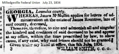
When south Georgia was first organized into counties in 1818, the area of present day Berrien County was originally part of old Irwin. The land lots and districts in Berrien County are still derived from the original plat of Irwin County. As related in a previous post (see Coffee’s Road Passed Seven Miles West of Ray City, the earliest roads in Berrien County date from shortly after the formation of Irwin. In writing on the local histories of Wiregrass Georgia counties, Folks Huxford made a number of references to the Coffee Road, portions of which are excerpted below.

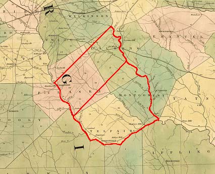
1822 Map Detail showing Irwin County, GA
The Coffee Road
The first two roads to be opened up in the new County of Irwin were the Roundtree Trail and the Coffee Road. The former extended from Pulaski County across the headwaters of the Alapaha River and entered present Tift County near Tifton, and then down the Little River. However, the Coffee Road became the great thoroughfare of travel.
It was the main thoroughfare from the older settled portion of the state into South Georgia and Florida; and practically all traffic from and into Florida west of the Okefenokee Swamp, was over that road. It led from Jacksonville on the Ogeechee [Ocmulgee] River in Telfair County, southwesterly through the then county of Irwin (but now Coffee, Irwin, Berrien) through the then county of Lowndes (but now Berrien, Cook and Brooks) into Thomas County and via Thomasville southwardly to the Florida line.
Coffee Road was opened up by the State under authority of an Act of the Legislature approved by Governor John Clark on December 23, 1822. It was significant that the road commenced at Governor Clark’s home town, Jacksonville, GA, and that the two men appointed to superintend the construction, John Coffee and Thomas Swain, were neighbors of the Governor. Swain was the operator of the ferry where the Coffee road crossed the Ocmulgee River near Jacksonville. Perhaps these three men foresaw the great stream of commerce which would flow down this road into south Georgia and Florida; and the political power of the time was in their favor.
The clearing of the road was undertaken at a cost of $1500.00 (see Coffee’s Road Passed Seven Miles West of Ray City. Enoch Hall, a Lowndes county pioneer and son of Sion Hall and Mrs. Bridget “Beady” Hall, was an overseer in laying out the route of the Coffee Road. Ed Cone, a Coffee Road researcher, observed “Mainly, it was built with slaves and volunteers. Some also suggest that the militia was involved, I find no evidence of this. There was reported to have been about forty slaves that were assigned to this project and Gen. Coffee probably paid their owners for their use.”
The road was duly opened and became known as the ‘Coffee Road’ from the fact that Gen. John Coffee of Telfair County, one of the Commissioners, had charge of its opening. It ran through the present counties of Berrien and Cook into Brooks and thence into present Thomas. It afforded the main highway of travel for some years down into Lowndes and Thomas and Decatur Counties and into West Florida.
Just two years after the opening of Coffee’s Road, Lowndes County was cut from Irwin. The area of Lowndes county was still a huge country which then included most of present day Berrien County and many surrounding counties. In those early days of Old Lowndes County, most of the settlement had occurred along the route of Coffee’s Road, or else along the Alapaha and Little rivers.
In 1830, a traveller reported in the Augusta Constitutionalist, “…the Coffee road, the route lying through a high pine barren country, affords level and dry roads. Indeed, for the little labor which has been bestowed upon them, they are in an uncommonly good state. Like the Indian trails, upon which many of the roads have been formed, they follow the indications of the trees and have generally only the inequalities of roots. There are no taverns on this route, but the housekeepers all entertain travellers. The accommodations are respectable, and the farmers kind and attentive to their guests and moderate in their charges.”
It should be noted that the route of the Coffee Road was somewhat fluid, as the location of bridges and ferries tended to change over time. In 1854, the Coffee Road was made the boundary between Coffee County and Irwin County, but the Legislature soon realized “the said Coffee road is undergoing changes every year, and subject to be altered and changed by order of the Inferior Courts of said counties.”
COFFEE ROAD WAYPOINTS
Jacksonville, GA Milepost 0
Ocmulgee Settlements
In Telfair county north of the Ocmulgee River… Major Mark Wilcox resided in this area prior to 1829. One of Wilcox’s enslaved men was an African-American named Luke, who was worked as a boat hand on the river from Darien to Macon.
Swain’s Ferry Milepost ~3
According to Ed Cone, General Coffee, a resident of Telfair County, began work on his road in 1823 at Thomas L. Swain’s Ferry on the Ocmulgee River near Jacksonville, Georgia (Telfair County). But at the 1831 July term of the Irwin County Inferior Court, “William Matchett, Daniel Grantham, Sr. and Micajah Paulk, Jr., [were] appointed to lay out and mark a road beginning at Thomas Swain’s ferry and running to Lowndes County line to intersect Coffee road,” The statement, from the History of Irwin County , is confusing but perhaps suggests Swain’s Ferry was not the original Coffee Road crossing over the Ocmulgee. By the January term, 1836, the “regular” route of the Coffee Road was over the Swain’s Ferry crossing and Frederick Merritt, Andrew McCelland and Micajah Paulk were appointed commissioners on the section of road from Swain’s ferry to Marsh’s ferry on the Alapaha River. If the remnants of the Old Coffee Road are still an indicator, Swain’s ferry was somewhere in the vicinity of Red Bluff or Mobley Bluff on the Ocmulgee River.
Widow Mobley’s Place Milepost ~4
Near the Coffee road at the edge of Ocmulgee Swamp
Graham Plantation Milepost ~9
Plantation of Duncan B. Graham, offered for sale Sept 2, 1855 in the Wiregrass News remained unsold in 1857, “situated on the Coffee Road, at the fork of the roads to Savannah, Augusta, and Tallahassee, six miles from Mobley’s Bluff, containing 980 acres, 40 acres under cultivation, with two settlements on the premises a half mile apart, with comfortable log buildings on each. Also a large quantity of excellent pine timber suitable for Ranging Timber, a good stand for a store and house of entertainment; also a variety of choice fruit trees, peaches, apples, figs, pears, &c. All of which will be sold at one 12-100 dollars per acre. The timber is worth at least four times as much as I ask for the premises, a part of which is only 4 1/2 miles from the bluff. I will also sell 75 or 80 head of meat hogs, stock hogs and crop on the premises. Cause for selling -the subscriber wishes to move to other lands in the same county. D.B. GRAHAM“
Leonard Harper’s Place Milepost ~18
Micajah Paulk’s Place Milepost ~28
Jacob Paulk’s Home-place Milepost ~32
Jacob Paulk’s Home-place was on the Coffee Road on a portion of Lot 10, 5th District of Irwin County, “about one mile north of Willacoochee Creek and six miles east of Ocilla. Paulks of America notes, “Paulk was described as having been a kindly disposed man, very hospitable and godly. He was the owner of many slaves of which he treated with kindness. He was ordained a deacon in the Brushy Creek Primitive Baptist Church.” Paulk was one of the builders of a great wolf trap near the church.
Willacoochee Creek Crossing Milepost ~33
As with other waypoints on the Coffee Road, the site of the Willacoochee Creek crossing necessarily changed over time.
Marsh’s Willacoochee Creek Ferry
In 1828, the Coffee Road crossed over Willacoochee Creek on Lot 381 in the 5th District of old Irwin County. Reuben Marsh, who located on this lot in 1828 established a ferry here.
Willacoochee Crossing on Lot 351
An 1869 map of Berrien County, GA faintly shows by that time the Coffee Road crossed over the Withlacoochee River on lot 351, 5th District. This crossing, bridge or ferry, was slightly north of the former Marsh’s ferry over the Willacoochee.
Micajah Paulk, Sr’s Place Milepost ~38
At least by 1838, the route of the Coffee road went by the home of Micajah’ Paulk, Senior, between the river crossing over Willacoochee Creek and the Alapaha River. It seems from Irwin County census, tax, land and court records that there were at least three men in old Irwin County, GA under the name Micajah Paulk. One of these men, known as Micajah Paulk, Sr, lived in the fork above the confluence of the Alapaha River and Willacoochee Creek. While the relations of the three men are not easily discernible, it is clear that this Micajah Paulk, Sr. was NOT the father of the well-known Micajah Paulk, Jr whose property was on the east bank of the Willacoochee River on land lots 289, 290, and 310 of the 5th district in Coffee County, where the Union Primitive Baptist Church is located, five miles north of Luke Bridge, and whose home was also on the Coffee Road more than five miles to the north.
Glory, GA Milepost ~41
Glory was a community that grew up along the Coffee Road in Berrien county. In 1906 it was described as, “a post village on the Atlantic Coast Line railroad, about twelve miles northeast of Nashville, GA. It has some stores, which do a good local business, and does considerable shipping. The population in 1900 was 54.”
Irwin Courthouse Road Junction Milepost ~42
This waypoint only lasted a year or two. From 1835, the next waypoint on the Coffee Road was the junction with the Irwin Courthouse Road. This road was ordered by the Irwin Inferior Court to run “from Irwin courthouse to Alapaha River at Marsh’s ferry.” The January 1835 court appointed Shadrach Griffin, Ruebin Gay and Richard Tucker to lay out and mark the road. “At January adjourned term, 1836, commissioners were authorized to turn the road leading from courthouse to Ruebin Marsh’s ferry on Alapaha to near John Benefield’s on to Elisha Grantham’s ferry on Alapaha and strike Coffee road nearest and best way.” Elisha Grantham’s Ferry apparently was upstream from Marsh’s Ferry on the Alapaha and provided a more direct route between the Irwin County Courthouse and the Lowndes County Courthouse.
Alapaha River Crossing Milepost ~42
It again appears there were several crossings of Coffee Road over the Alapaha River, being in service at different places and times.
Marsh’s Ferry
William Green Avera stated that in the early days of the county, Coffee Road crossed the Alapaha River at Marsh Ferry. James Bagley Clements’ History of Irwin County documents in numerous places that Reuben Marsh operated a ferry across the Alapaha River by 1835. An Inferior Court order in 1842 appears to be a re-authorization of Marsh’s Ferry: “At the January term, 1842, an order was passed by the Inferior Court [Irwin County] an order was passed establishing a ferry across the Alapaha River at a place known as Marshes Ferry. The rates were fixed as follows: man and horse, twelve and one-half cents; man, horse and cart, twenty-five cents; two-horse wagon, fifty cents; four-horse wagon, one dollar; pleasure carriages, one dollar; gigs, fifty cents; jersey wagons, thirty-seven and one-half cents; mules and horses, 3 cents per head; cattle, 3 cents per head, sheep and hogs, one and one-half cents per head; foot persons, free. Rates to be advertised at ferry.”
Lopahaw Bridge
The General Assembly acted in 1836 to fund the construction of a bridge across the Alapaha River stating”it is all important that a bridge should be built across the Lopahaw, at or near Coffee’s Road.” According to the Legislative Act authorizing the Coffee Road, it crossed the Alapaha “at or near Cunningham’s ford on said river.” In 1836 a public bridge was constructed over the river, but this bridge was condemned at the January 1856 term of the Irwin County Inferior Court.
Tyson’s Ferry
At the 1856 term of the Irwin County Inferior Court, according to James Bagley Clements’ History of Irwin County, “Cornelious Tyson was granted authority to erect a ferry on Alapaha River on the Coffee road at the location of the condemned bridge and he is allowed to charge the following rates: man and horse, six and one-fourth cents; horse and cart, twenty-five cents; four-horse wagon, fifty cents; horse and buggy, thirty-seven and one-half cents.” An 1869 District Survey Plat of Berrien County places Tyson’s Ferry on Lot
Cornelius Tyson’s Place Milepost ~44.0
Cornelius Tyson’s home place according to 1836 Irwin County court records was on or near the Coffee Road. His property as shown in the county tax records of 1831 and 1832 included Lots 422 and 424 in the 5th Land District of Irwin County. Lot 424 straddled the Alapaha River and Lot 422 was just southeast of the river. His place was within the area that was later cut into Berrien County in 1856, Tyson being one of the five marking commissioners appointed by the state legislature in 1856 to fix the boundary lines of the newly created Berrien County. He was one of the original Inferior Court judges of Berrien County. Cornelius Tyson is enumerated in Berrien County, GA as Cornelius Tison in the Census 1860.
The Kirby Place Milepost ~53
Farm and residence of William Kirby and Amy Griner Kirby. The Kirbys were married in Bulloch County, GA in 1822 and came to Lowndes County, GA about 1829 settling just north of Mrs. Kirby’s parents“on the Coffee Road, one mile northeast of the present site of Nashville lCourt House]”. Mr. Kirby died in 1855. The widow Kirby’s place was the site of the first session of the Berrien County Superior Court held in November, 1856, according to William Green Avera. Mrs. Kirby was a daughter of Emanuel Griner.
The Griner Place Milepost ~54
Emanuel Griner in 1829 brought his family from Bulloch county to then Lowndes County, GA where he settled on the Coffee Road at the present site of Nashville, Berrien County. His son, Daniel Griner, established a residence on land situated on the northwest corner of present day Marion Avenue and Davis Street. Nashville, GA was founded about 1840 and in 1856, was designated seat of the newly formed Berrien County. In that year, Daniel Griner sold a portion of his farm to the Inferior Court to become the site of the first Berrien County Court House.
Withlacoochee River Crossing Milepost ~63
Likewise, the Coffee Road had multiple crossings over the Withlacoochee River, at different places and different times.
Futch’s Ferry
Futch’s Ferry was a later crossing at the Withlacoochee River on the Coffee Road.
Among the earliest waypoints on the Coffee Road were the homes of David Mathis, Sion Hall, Daniel McCranie, Hamilton Sharpe, and James Lovett.
McCranie’s Post Office Milepost ~64
“The first post office in original Lowndes County was established in 1827 at the home of Daniel McCranie in present Cook County. This was on the Coffee Road. The Coffee Road was the main stagecoach route from the upper part of the state, and was also the mail route.” According to the Record of Connell-Morris and Allied Families, Daniel McCranie’s place was on Land Lot 416 in the 9th District of original Irwin County, GA. He purchased this land and built his home in 1824.
Richard Parr Hutchinson’s Place Milepost ~65
A Brother-in-law of William Smith, innkeeper at Franklinville and Troupville. In 1850 Richard Parr Hutchinson settled three miles east of where the village of Cecil now is, on the Coffee Road. In time he acquired several thousand acres of land and had a large stock of cattle. At the close of the war he had forty-eight slaves that were emancipated, thus losing much of his accumulated estate. Among his real estate was the old Hutchinson’s Mill and the millpond which is still bears his name.
William T. Varn’s Place Milepost ~67
In 1836, in company with his brother, Frederick Varn, the two families moved from their old home in Colleton County, SC to Lowndes county, GA and settled a few miles apart…William T. settled on the Coffee Road about 1 1/2 miles east of the present village of Cecil, GA. -POWG Vol III
Hutchinson Mill Creek Crossing Milepost ~68
Mathis House Stagecoach Stop Milepost ~69
In January 1826, David Mathis built a log home, a sturdy and comfortable home for his wife, Sarah Monk, and family. This home was on the Coffee Road, one mile east of the present village of Cecil, Cook County. It was a stagecoach stop where the horses were rested. Many people in those pioneer days enjoyed the hospitality of the Mathis home.
Frank’s Creek Crossing Milepost ~71
Frederick Varn’s Place
In 1836 Frederick Varn brought his family from Colleton County, SC to settle near present Salem Methodist Church. After about three years, Frederick Varn moved on to Florida. -POWG Vol III
Salem Church (Est. 1856) Milepost ~72
Salem Methodist Church was built on then Coffee Road (now Salem Church Road) in 1856, on land that was deeded by Eli Driver Webb. The first trustees were Randall Folsom, Joseph T. Webb, William Varn, William D. Smith and Berry J. Folsom. It is believed that the first pastor of Salem was either Rev. Joseph T. Webb or Rev. Hamilton W. Sharpe, both local Methodist preachers of that era…The exact year this church was organized is unknown but it is believed that the original church building was a small log structure constructed near a spring fed branch behind the present 110-year-old home place of Mr. and Mrs. Lewis Folsom. – South Georgia Conference of the United Methodist Church
Public School (circa 1856)
“Many of the citizens of the community attended school in a one-room school across” Coffee Road from Salem Methodist Church “and, when needed, the church was also used for classroom space.” – South Georgia Conference of the United Methodist Church– South Georgia Conference of the United Methodist Church
Junction with Franklinville Road Milepost ~74
The Franklinville road joined the Coffee Road just east of Little River. It ran 11 miles east to Franklinville, founded 1827 as the first County Seat of Lowndes County. The connection provided a direct route from Franklinville to Thomasville, seat of Thomas County.
Little River Crossing
Joyce’s Ferry Mile Post ~75
Washington Joyce’s Ferry over the Little River on the Coffee Road. According to Robert Edward Lee Folsom’s 1889 Historical Sketch of Lowndes County, In 1824… Washington Joyce settled on the east bank of the Little River, and built a ferry at what is now the Miller Bridge. In this regard, it seems REL Folsom’s account may be confused. The route of Old Coffee Road west of Little River suggests that Joyce’s Ferry was at or near the location of the present day Hwy 122 bridge, not at the site of Miller Bridge. Washington Joyce’s home site was the first white settlement in present [1899] Lowndes county. His father, Henry Joyce, had operated ferries across the Ocmulgee River,and the Oconee River. An 1832 a bill introduced in the Georgia legislature seems to incorrectly place Joyce’s Ferry on the Withlacoochee River, said bill “to open and define a road from Hawkinsville, Pulaski County, through the counties of Irwin and Lowndes, the said road to be laid out and defined on the route now known as Roundtree’s Trail, to intersect Coffee’s road, at or near Joyce’s ferry, on the Withlockcoochee [Withlacoochee?].” Some time before 1840, Washington Joyce moved to Randolph County, GA.
Folsom Bridge
Replaced Joyce’s Ferry. Another waypoint on the Coffee Road, to the northeast of Hall’s Inn, was the Folsom Bridge, where Coffee’s Road crossed the Little River. William Folsom’s place was located about a mile and a half east of the bridge.
Miller Bridge Milepost ~77 (on rerouted Coffee Road).
A later crossing over the Little River two miles down river from Joyce’s Ferry. This southern route to present day Morven, GA would have bypassed Hall’s Inn.
Hall’s Inn Milepost ~77
The home of Sion Hall, who had settled in the territory of present day Brooks County near Morven immediately upon the opening of Coffee Road in 1823, was the county’s earliest tavern. Hall’s home was the place of the first Superior Court in Lowndes County, with Judge Thaddeus G. Holt presiding and Levi J. Knight foreman of the Grand Jury. Being located on the only thoroughfare in the section, ” it was therefore accessible to other pioneers settling in the area. When Lowndes county was being organized, the Georgia legislature designated Hall’s residence as the site for elections and county courts, until such time as a permanent site could be selected. The Sion Hall home was situated about 1 1/2 miles northward from Morven, and was on land lot No. 271, in the 12th District of old Irwin County…. The home of Hon. Sion Hall was a public inn on the Coffee Road for many years, and many people stopped there for a meal or to spend the night, and the place found favor with the traveling public. The Hall home was capable of accommodating as many as twelve or fifteen people at one time without inconvenience. Overflow guests were allowed to sleep on improvised beds on the floor. ‘Hall’s’ was always a stopping point usually for the night for judges and lawyers going from Troupville to Thomasville during the semi-annual court sessions.”
Pike Branch Crossing Milepost ~78
Captain John J. Pike was a son-in-law of Sion Hall. Pike led a company of men in the 1836 Battle of Brushy Creek. He died in 1837 in Lowndes County, GA at the age of 39.
Mount Zion Camp Ground
Near Coffee Road immediately south of Pike Branch. According to a historical marker on the site, “The first Camp Meeting was held on this site in 1828 by a “few scattered Methodists” before any Methodist Church in the area was organized. William Hendry, William Blair and Hamilton W. Sharpe, as a committee, selected the site. Rev. Adam Wyrick was the first visiting preacher. In 1831 Sion and Enoch Hall deeded the land on which the Camp Ground stood to the Methodist Episcopal Church. Housed first in a brush-arbor, the weeklong meetings were held without interruption until 1881. Then the camp meetings ceased and the nearby church was built. Meetings were practically continuous each day from sunrise until after “candle-lighting.”
Sharpe’s Store Milepost ~78
“The next point of interest on the Coffee Road after leaving McCranie’s post office was ‘Sharpe’s Store‘ which was in present Brooks County and situated some fifteen miles westward from old Franklinville [approximately 25 miles southwest of the point where the Knights settled at the present day site of Ray City, GA]. Hamilton W. Sharpe, then a young man hardly in his twenties, had come down from Tatnall County over the Coffee Road, and decided to locate near the home of Hon. Sion Hall at whose home the first court in Lowndes was held a few months afterwards. So young Sharpe built a small store building out of logs near the Sharpe home; that was in 1826. He along with others expected that the permanent county-seat would be established there. A post office was established at Sharpe’s Store in 1828.
Reverend Howren’s Place (1836)
Reverend Robert H. Howren brought his family to old Lowndes County in 1836 as conflicts with Native Americans were rising in Florida and Georgia. The Howren’s settled on Coffey’s Road and became neighbors of fellow Methodist Hamilton W. Sharpe.
Land of B. W. Sinclair (1844) Milepost ~80
At approximately Mile Marker 80, The Coffee Road entered the northeast corner of Land Lot 314, Land District 12 of old Irwin County. This was state-owned wildlands until purchased from the state by John G Park of Baldwin County, GA. 15 February 1842. Benjamin W. Sinclair had Lot 314 and adjacent Lot 331 re-surveyed in 1844 by Jeremiah Wilson, County Surveyor of Brooks County.
Sim Philips Place Milepost ~83
Okapilco Creek Bridge Milepost ~88
The 1827 Coffee Road crossing over Okapilco Creek was about ten miles west of Sharpe’s Store. Thomas Spalding, traveling with an expedition to survey the Georgia-Florida line, in his journal called this “the Oakfeelkee Bridge, which had been erected by Gen. Coffee;” the expedition crossed the bridge on March 30, 1827. According to mapping done by the Wiregrass Region Digital History Project, this section of the Coffee Road followed a route south of present day Coffee Road, such that the 1827 Okapilco Bridge was about 1.5 miles down stream of the present Coffee Road crossing road over the creek.
Little Creek Ford Milepost ~85
About a half mile west of Okapilco Creek the Coffee road forded a small tributary of Mule Creek.
Bryant Settlement Milepost ~86
According to Robert Edward Lee Folsom, “The first white settlement in this [old Lowndes County] section was made on this [Coffee] road in the fork of the Okapilco and Mule creeks in Brooks county, at an old Indian town, by Jose Bryant, in 1823.”
Hendry‘s Mill Milepost ~87
Another three quarters of a mile west at the crossing of Mule Creek was Hendry’s Mill. William Hendry and Nancy McFail Hendry brought their family from Liberty County, GA to Lowndes County (now Brooks) about 1827, and settled in the vicinity where Coffee Road crosses Mule Creek, about midway between Pavo and Quitman, GA. William Hendry was one of the prominent citizens of Lowndes County in his day…his upright and godly life and character has been handed down, by word of mouth, to the present generation. The Hendrys seem to have had skill building and operating mills in Liberty County and again on Mule Creek in his new home. He erected the first water driven mill in this part of Georgia.
Okapilco Baptist Church (Est. 1861) Mile Post ~89
Okapilco Baptist Church was organized on Feb. 21, 1861. This church was an important church in that it represented an early place of worship for the early settlers in that area.
Lovett’s Dinner House Mile Post ~97
Lovett’s Dinner House was about 10 miles west of Hendry’s Mill. “There were no further inns on the Coffee Road until James Lovett’s home and inn was reached, which was about fifteen miles east of Thomasville near the then Lowndes and Thomas county line. Lovett’s was reached about noon after setting out from Hall’s after breakfast. Most travelers stopped there for dinner, hence Lovett’s hospitable home was called a ‘dinner house.'” According to Ed Cone’s Coffee Road website, “This dinner-house was operated by James Lovett and is located at the crossroad of the Salem Church Road and the Coffee Road about two miles west of Barwick, GA. James Lovett married Catherine (Katy) Zitterauer and they are the parents of Rachel Lovett who married James Cone. They are ancestors of a large Cone family in Thomas County. The “Lovett’s Dinnerhouse has been remodeled but still stands.”
Robert Ivey’s Place Milepost ~102
Established before 1828 “eight miles above Thomasville, on Coffee’s road.”
Aucilla River Ford Milepost ~103
About five miles west of Lovett’s place the Coffee Road crossed over the headwaters of the Aucilla River. Thomas Spalding, traveling Coffee Road on an expedition to survey the Florida-Georgia boundary, recorded in his journal on March 31, 1827, “crossed the Ocilla [Aucilla] a small stream where we crossed it, a few miles below, we understand it swells into a lake, after receiving 3 or 4 streamlets from the west.”
Mr. Horn’s Place
Thomas Spalding recorded in his journal on March 31, 1827, “At Mr. Horn’s near one of the streams of this river [Aucilla], we met with good land, and some extension of improvement, he had resided here 6 years, and was a fine looking old man. — He had been forted, and was just taking down the palisades, erected as defence against the Indians. We were now in the vicinity where the late Indian murders were committed, and we had confirmed from his lips that we had previously heard, that these deaths and plunderings, and expence, were produced by two scoundrel young men; who had stolen some Indian horses, and fled into South Carolina with them, their names were known, and if they themselves are not living here, their brothers are. Their circumstances are familiar to every one — yet the law sleeps.”
Gatlin Plantation Milepost ~106
T.M. Gatlin “offers for sale his Plantation situated four miles east of Thomasville, on the Coffee Road, consisting of 1800 acres, with plenty of woodland for fencing and other purposes. A dwelling, Gin-house, Screw and other buildings essential to farming, are upon the premises, and location favorably situated for health. The place is well watered with never-failing streams and has a fine mill-seat.” -Wiregrass Reporter Nov 3 1857
Thomasville, GA Milepost ~110
On December 24, 1825, …. Five commissioners were named to select a county seat for Thomas, purchase a land lot or land lots, and lay off lots for sale to the public. These early commissioners were Duncan Ray, William J. Forson, Simon Hadley, Sr., Michael Horn, and John Hill Bryan (who was probably “Thomas” Hill Bryan ) …The commissioners purchased lot 39 (in the 13th district of old Irwin) next to the Kingsley place from Thomas Johnson for $210, and this site was declared the county seat. One Aaron Everett was employed to lay off and survey a courthouse square and other adjacent lots. Soon these lots were sold at public sale but brought low prices. Consequently, on December 22, 1826, an act of the legislature declared ‘the courthouse and jail of said County of Thomas is hereby made permanent at a place now known and called by the name of Thomasville, and shall be called and known by that name.’ By 1827 Thomasville was an outpost in a pine wilderness. A courthouse was built of roughly split pine logs. In November, 1827, Superior Court was held, and Judge Fort sentenced three Indians to be hanged for murdering Phillip and Nathan Paris, white men who lived in the Glasgow District of the county. Moreover, there were a few dwellings. E. J. Perkins had a home and grocery. Nearby was another home, and James Kirksey operated a store, although this soon burned. One of the first important stores was run by Simon A. Smith and his son. Other families moved in and in 1831 the small settlement was incorporated. Isaac P. Brooks, Edward Remington, Malcolm Ferguson, James Kirksey, and Murdock McAwley were appointed commissioners for the town. – Ante-bellum Thomas County, GA
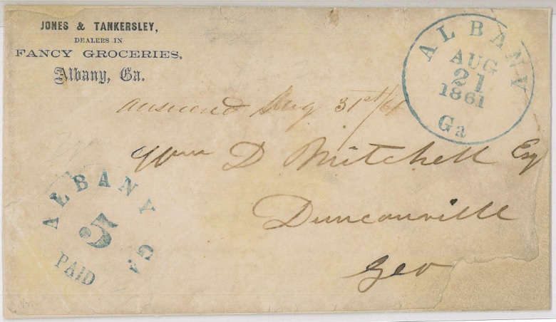
Duncanville, GA Milepost ~122
Said by REL Folsom to be the southern terminus of the Coffee Road in Georgia. According to the Table of Post Offices, in 1830 Duncanville was one of only two post offices in all of Thomas County, GA. The postmaster was William Coggins. According to the January 8, 1859, issue of the Georgia Watchman the Duncanville District was the location of the plantation of General Thomas E. Blackshear, who commanded the 69th Regiment, Georgia Militia in the Indian Wars of 1836.
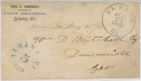
1861 letter envelope addressed to W. D. Mitchell, Duncanville, GA
Georgia-Florida Boundary. Milepost ~125
About 15 miles south of Thomasville.
Tallahassee, Florida Milepost ~145
Construction and Maintenance of Coffee Road
“The Coffee Road was maintained by road-hands in the various counties through which it passed, and was in no sense a state road as would be understood nowadays. The only part the state had was in the opening of it before people ever settled in the territory through which it passed. Gen. Coffee, at the expense of the State, employed a crew of men, some thirty or forty, free-labor, and with the help of state surveyors, projected the road through a wild and uninhabited territory. It was just wide enough for two vehicles to pass and was not ditched or graded as is done at present (roads never had ditches until after the Civil War and very few then for many years). “
The streams were either “forded” or crossed by means of ferries owned by private individuals. Fares for ferries were fixed in each county in those days by the Inferior Court. In times of high water the streams which were “forded” would often “swim” the horse and vehicle for two or three days and at times even longer, and only those on horse-back could have any reasonable hope of making a trip without interruptions. There were no bridges on any of the streams until after the Civil War.
The 1829 Gazetteer of the State of Georgia, in describing the road from Milledgeville to Tallahassee, stated:
“This is a stage road once a week. Fare $25. Leaves Milledgeville on Wednesdays… The road via Jacksonville and Thomasville is [246 miles] and is destitute of water for many miles.”
Using a historic standard of living for comparison, the $25 fare would have equated to about $612 in 2010 dollars.

Charles Joseph La Trobe, an early traveler on the Coffee Road, wrote about his experiences in 1835.
In 1833, Charles Joseph La Trobe, an English traveler and writer, rode from Tallahassee, FL to Milledgeville, GA via the weekly stagecoach. Before departing Tallahassee, La Trobe apparently sampled the local hospitality:
In referring to Tallahassee beverages, the traveler [La Trobe] described the mint-julep, mint-sling, bitters, hailstone, snowstorm, apple-toddy, punch, Tom and Jerry and egg-nogg. He was about to give the recipe for mint-julep when he used the following language: “Who knows, that if you get hold of the recipe, instead of being an orderly sober member of society, a loyal subject, and a good Tory; you will get muzzy, and hot-brained, and begin to fret about reform, and democratic forms of government, – doubt your bible – despise your country – hate your King – fight cocks, and race like a Virginian – swear profanely like a Western man – covet your neighbors’ goods like a Yankee speculator – and end by turning Radical Reformer!” –Thomasville Times, Jun. 22, 1889 — page 7
Despite his warnings to others, La Trobe made notes on the recipes of these concoctions for his own personal use. One wonders if the aftereffects of too much ‘Julep’ were not causative of the ill description of the trip to Milledgeville in his book, “The Rambler in North America:
“…we were well aware that there was some sore travelling in advance. The roads through the south of Georgia are in the roughest state. The public vehicle which, as it happened, we had all to ourselves, rattled however over the country, when practicable, at the heels of a pair of stout young horses, from stage to stage, with a good-will and rapidity, which would have been very satisfactory, had the impediments in the roads and in the state of the crazy carriage permitted constant advance; but we only reached Milledgeville, the capital of Georgia, after three days and nights of incessant travel and that after a goodly proportion of breakdowns and stickfasts, besides having to wade many deep creeks and swim one or two.
The streams were all flooded and ferries and bridges were seldom seen and I would rather take my chance for swim than pass over the rocking and fearful erection they call a bridge which under that name span many of the deep rivers on the road nearer the coast, and however rotten, are seldom repaired till some fatal accident renders the repair imperative. Yet the coolness with which the coachman, after halting for a moment on the edge of the steep broken declivity, and craning forward to look at the stream in advance, broad, muddy, and rapid, running like a mill-race, will then plunge into it with his horses, descending down till the water covers their backs, is admirable. On these occasions we always thought that a preparation to swim was no sign of cowardice, and made our precautions accordingly. From all this you may gather that travelling in the South is still in its infancy, and I may add shamefully expensive. You pay exorbitantly for the meanest fare.
Of the scenery, I need say but little. A great proportion of our route lay over an uninteresting pine-covered country, but there were frequent towns springing up along the line which will doubtless become more and more frequent…’
Prior to the opening of the Coffee Road in 1823, there were very few pioneer families in all of Irwin County ( then encompassing present day Lowndes, Thomas, Worth, Berrien, Cook, Brooks, Coffee Lanier, Tift, Turner, Ben Hill, Colquitt, and parts of Echols and Atkinson counties). Folks Huxford dated the earliest settlement of present day Brooks County. originally part of Lowndes, as occurring in 1823 after the Coffee Road was opened.
“The influx of settlers was so great that within two years after the Coffee Road was opened up there had moved in approximately two hundred families, so that the southern half of the county [of Irwin] was cut off and made into the new County of Lowndes.

Mapquest Route connecting remaining sections of Coffee Road.